You are here: Home > Network List > TA - USArray Transportable Network (new EarthScope stations) Stations List
> Station R56A Bull Pasture Mountain, McDowell, VA, USA > Earthquake Result Viewer
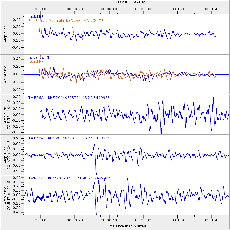
R56A Bull Pasture Mountain, McDowell, VA, USA - Earthquake Result Viewer
*The percent match for this event was below the threshold and hence no stack was calculated.
| Earthquake location: |
Chile-Bolivia Border Region |
| Earthquake latitude/longitude: |
-20.2/-68.7 |
| Earthquake time(UTC): |
2014/07/23 (204) 21:39:08 GMT |
| Earthquake Depth: |
115 km |
| Earthquake Magnitude: |
5.5 M |
| Earthquake Catalog/Contributor: |
NEIC PDE/NEIC COMCAT |
|
| Network: |
TA USArray Transportable Network (new EarthScope stations) |
| Station: |
R56A Bull Pasture Mountain, McDowell, VA, USA |
| Lat/Lon: |
38.41 N/79.40 W |
| Elevation: |
902 m |
|
| Distance: |
59.2 deg |
| Az: |
350.222 deg |
| Baz: |
168.288 deg |
| Ray Param: |
$rayparam |
*The percent match for this event was below the threshold and hence was not used in the summary stack. |
|
| Radial Match: |
72.04472 % |
| Radial Bump: |
400 |
| Transverse Match: |
58.847202 % |
| Transverse Bump: |
400 |
| SOD ConfigId: |
751272 |
| Insert Time: |
2014-08-06 22:33:48.277 +0000 |
| GWidth: |
2.5 |
| Max Bumps: |
400 |
| Tol: |
0.001 |
|
Signal To Noise
| Channel | StoN | STA | LTA |
| TA:R56A: :BHZ:20140723T21:48:26.349998Z | 1.2344794 | 9.124868E-8 | 7.391673E-8 |
| TA:R56A: :BHN:20140723T21:48:26.349998Z | 1.4332248 | 1.0107279E-7 | 7.052124E-8 |
| TA:R56A: :BHE:20140723T21:48:26.349998Z | 0.8132531 | 4.8264756E-8 | 5.9347766E-8 |
| Arrivals |
| Ps | |
| PpPs | |
| PsPs/PpSs | |


