You are here: Home > Network List > US - United States National Seismic Network Stations List
> Station CBKS Cedar Bluff, Kansas, USA > Earthquake Result Viewer
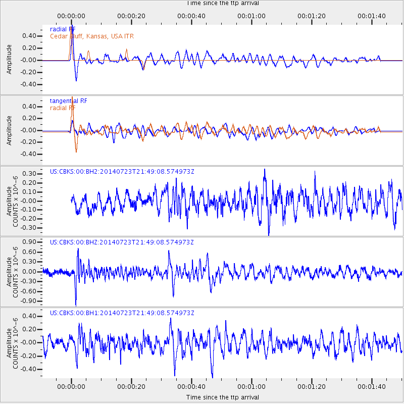
CBKS Cedar Bluff, Kansas, USA - Earthquake Result Viewer
*The percent match for this event was below the threshold and hence no stack was calculated.
| Earthquake location: |
Chile-Bolivia Border Region |
| Earthquake latitude/longitude: |
-20.2/-68.7 |
| Earthquake time(UTC): |
2014/07/23 (204) 21:39:08 GMT |
| Earthquake Depth: |
115 km |
| Earthquake Magnitude: |
5.5 M |
| Earthquake Catalog/Contributor: |
NEIC PDE/NEIC COMCAT |
|
| Network: |
US United States National Seismic Network |
| Station: |
CBKS Cedar Bluff, Kansas, USA |
| Lat/Lon: |
38.81 N/99.74 W |
| Elevation: |
677 m |
|
| Distance: |
65.6 deg |
| Az: |
333.74 deg |
| Baz: |
147.874 deg |
| Ray Param: |
$rayparam |
*The percent match for this event was below the threshold and hence was not used in the summary stack. |
|
| Radial Match: |
73.7429 % |
| Radial Bump: |
400 |
| Transverse Match: |
59.119465 % |
| Transverse Bump: |
400 |
| SOD ConfigId: |
751272 |
| Insert Time: |
2014-08-06 22:37:27.950 +0000 |
| GWidth: |
2.5 |
| Max Bumps: |
400 |
| Tol: |
0.001 |
|
Signal To Noise
| Channel | StoN | STA | LTA |
| US:CBKS:00:BHZ:20140723T21:49:08.574973Z | 5.120992 | 3.3431672E-7 | 6.528359E-8 |
| US:CBKS:00:BH1:20140723T21:49:08.574973Z | 1.7957633 | 1.5512276E-7 | 8.6382634E-8 |
| US:CBKS:00:BH2:20140723T21:49:08.574973Z | 1.7697797 | 1.2966001E-7 | 7.326336E-8 |
| Arrivals |
| Ps | |
| PpPs | |
| PsPs/PpSs | |


