You are here: Home > Network List > US - United States National Seismic Network Stations List
> Station MNTX Cornudas Mountains, Texas, USA > Earthquake Result Viewer
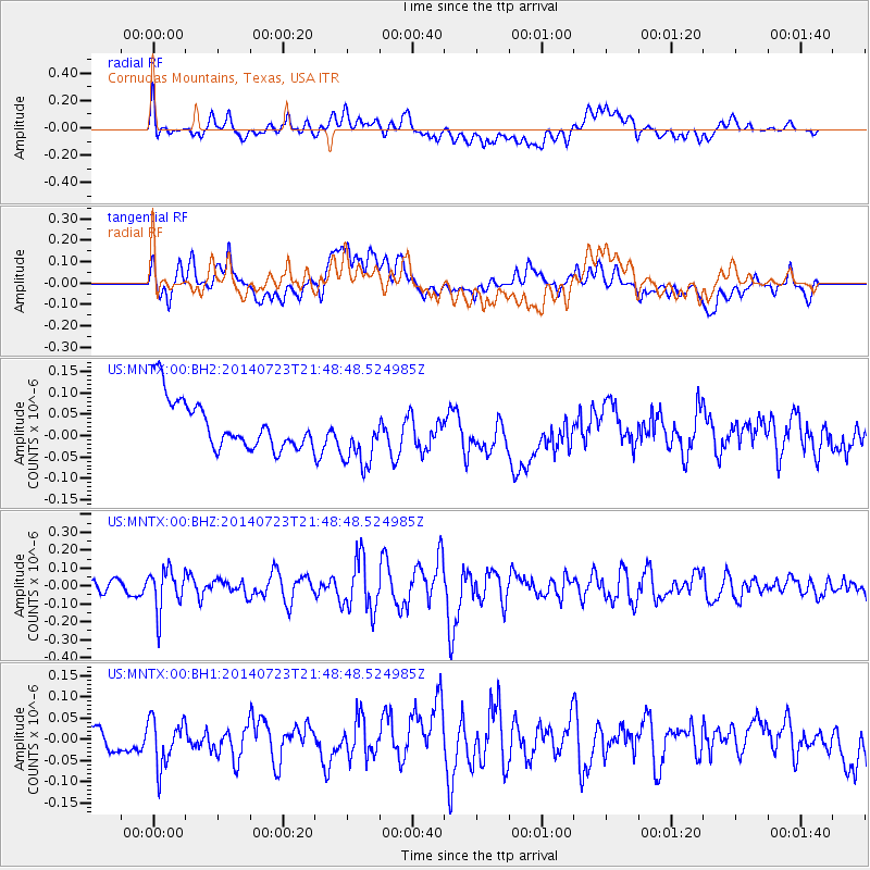
MNTX Cornudas Mountains, Texas, USA - Earthquake Result Viewer
*The percent match for this event was below the threshold and hence no stack was calculated.
| Earthquake location: |
Chile-Bolivia Border Region |
| Earthquake latitude/longitude: |
-20.2/-68.7 |
| Earthquake time(UTC): |
2014/07/23 (204) 21:39:08 GMT |
| Earthquake Depth: |
115 km |
| Earthquake Magnitude: |
5.5 M |
| Earthquake Catalog/Contributor: |
NEIC PDE/NEIC COMCAT |
|
| Network: |
US United States National Seismic Network |
| Station: |
MNTX Cornudas Mountains, Texas, USA |
| Lat/Lon: |
31.70 N/105.38 W |
| Elevation: |
404 m |
|
| Distance: |
62.5 deg |
| Az: |
324.961 deg |
| Baz: |
140.769 deg |
| Ray Param: |
$rayparam |
*The percent match for this event was below the threshold and hence was not used in the summary stack. |
|
| Radial Match: |
49.886013 % |
| Radial Bump: |
400 |
| Transverse Match: |
41.7125 % |
| Transverse Bump: |
400 |
| SOD ConfigId: |
751272 |
| Insert Time: |
2014-08-06 22:38:57.919 +0000 |
| GWidth: |
2.5 |
| Max Bumps: |
400 |
| Tol: |
0.001 |
|
Signal To Noise
| Channel | StoN | STA | LTA |
| US:MNTX:00:BHZ:20140723T21:48:48.524985Z | 1.9920185 | 1.14951106E-7 | 5.7705844E-8 |
| US:MNTX:00:BH1:20140723T21:48:48.524985Z | 1.3398284 | 5.7197575E-8 | 4.2690225E-8 |
| US:MNTX:00:BH2:20140723T21:48:48.524985Z | 1.2669017 | 7.195231E-8 | 5.6793912E-8 |
| Arrivals |
| Ps | |
| PpPs | |
| PsPs/PpSs | |


