You are here: Home > Network List > UW - Pacific Northwest Regional Seismic Network Stations List
> Station MRBL Marblemount, WA, USA > Earthquake Result Viewer
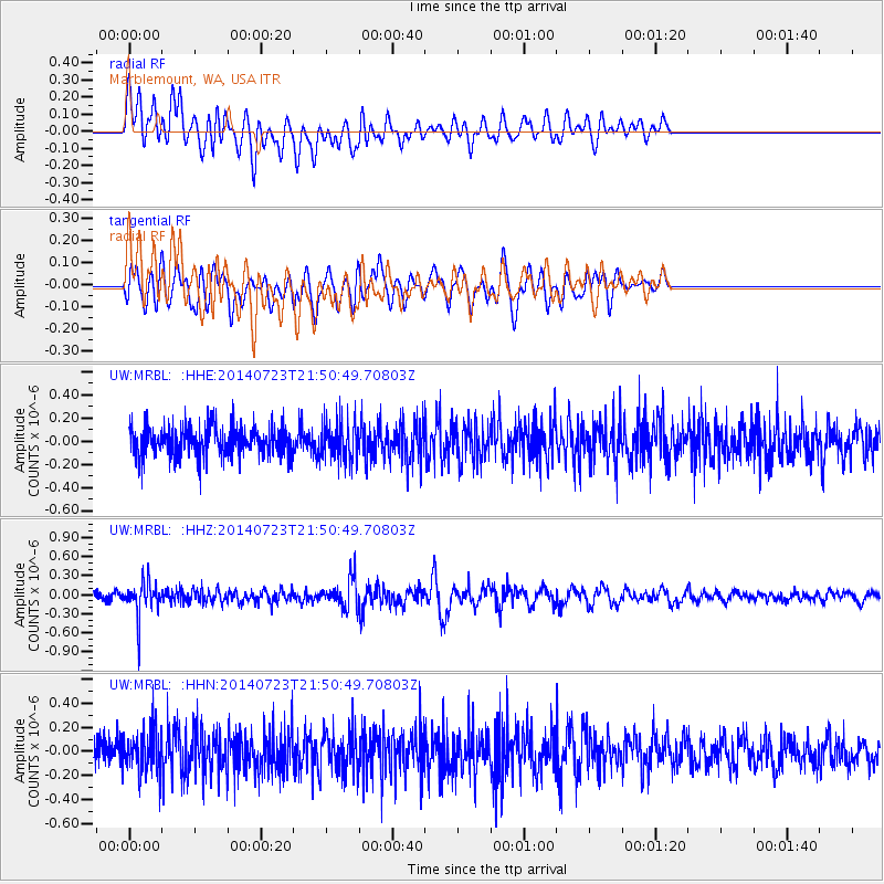
MRBL Marblemount, WA, USA - Earthquake Result Viewer
*The percent match for this event was below the threshold and hence no stack was calculated.
| Earthquake location: |
Chile-Bolivia Border Region |
| Earthquake latitude/longitude: |
-20.2/-68.7 |
| Earthquake time(UTC): |
2014/07/23 (204) 21:39:08 GMT |
| Earthquake Depth: |
115 km |
| Earthquake Magnitude: |
5.5 M |
| Earthquake Catalog/Contributor: |
NEIC PDE/NEIC COMCAT |
|
| Network: |
UW Pacific Northwest Regional Seismic Network |
| Station: |
MRBL Marblemount, WA, USA |
| Lat/Lon: |
48.52 N/121.48 W |
| Elevation: |
75 m |
|
| Distance: |
83.1 deg |
| Az: |
327.767 deg |
| Baz: |
131.127 deg |
| Ray Param: |
$rayparam |
*The percent match for this event was below the threshold and hence was not used in the summary stack. |
|
| Radial Match: |
70.66121 % |
| Radial Bump: |
400 |
| Transverse Match: |
59.15083 % |
| Transverse Bump: |
400 |
| SOD ConfigId: |
751272 |
| Insert Time: |
2014-08-06 22:42:05.651 +0000 |
| GWidth: |
2.5 |
| Max Bumps: |
400 |
| Tol: |
0.001 |
|
Signal To Noise
| Channel | StoN | STA | LTA |
| UW:MRBL: :HHZ:20140723T21:50:49.70803Z | 4.108037 | 2.7264517E-7 | 6.636873E-8 |
| UW:MRBL: :HHN:20140723T21:50:49.70803Z | 1.4648956 | 1.8165217E-7 | 1.2400349E-7 |
| UW:MRBL: :HHE:20140723T21:50:49.70803Z | 1.3277103 | 1.7024584E-7 | 1.2822514E-7 |
| Arrivals |
| Ps | |
| PpPs | |
| PsPs/PpSs | |


