You are here: Home > Network List > UW - Pacific Northwest Regional Seismic Network Stations List
> Station UMAT Pilot Rock, OR, USA > Earthquake Result Viewer
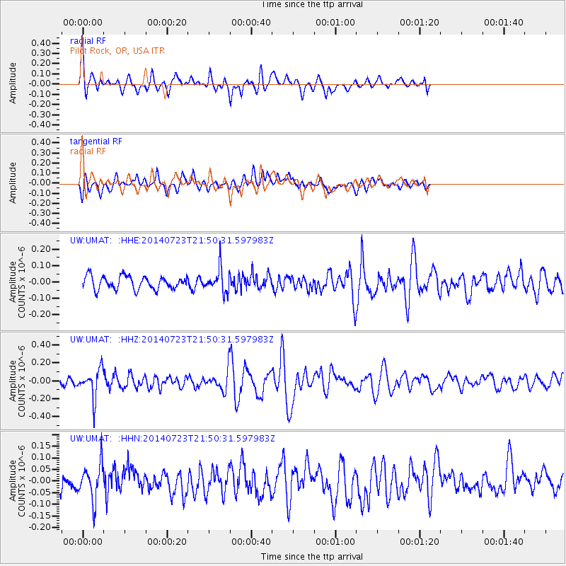
UMAT Pilot Rock, OR, USA - Earthquake Result Viewer
*The percent match for this event was below the threshold and hence no stack was calculated.
| Earthquake location: |
Chile-Bolivia Border Region |
| Earthquake latitude/longitude: |
-20.2/-68.7 |
| Earthquake time(UTC): |
2014/07/23 (204) 21:39:08 GMT |
| Earthquake Depth: |
115 km |
| Earthquake Magnitude: |
5.5 M |
| Earthquake Catalog/Contributor: |
NEIC PDE/NEIC COMCAT |
|
| Network: |
UW Pacific Northwest Regional Seismic Network |
| Station: |
UMAT Pilot Rock, OR, USA |
| Lat/Lon: |
45.29 N/118.96 W |
| Elevation: |
1318 m |
|
| Distance: |
79.6 deg |
| Az: |
326.509 deg |
| Baz: |
132.776 deg |
| Ray Param: |
$rayparam |
*The percent match for this event was below the threshold and hence was not used in the summary stack. |
|
| Radial Match: |
60.818287 % |
| Radial Bump: |
400 |
| Transverse Match: |
63.607437 % |
| Transverse Bump: |
400 |
| SOD ConfigId: |
751272 |
| Insert Time: |
2014-08-06 22:42:29.352 +0000 |
| GWidth: |
2.5 |
| Max Bumps: |
400 |
| Tol: |
0.001 |
|
Signal To Noise
| Channel | StoN | STA | LTA |
| UW:UMAT: :HHZ:20140723T21:50:31.597983Z | 2.9111817 | 1.6313349E-7 | 5.6036864E-8 |
| UW:UMAT: :HHN:20140723T21:50:31.597983Z | 1.6697748 | 7.933202E-8 | 4.751061E-8 |
| UW:UMAT: :HHE:20140723T21:50:31.597983Z | 1.8089007 | 7.183888E-8 | 3.971411E-8 |
| Arrivals |
| Ps | |
| PpPs | |
| PsPs/PpSs | |


