You are here: Home > Network List > II - Global Seismograph Network (GSN - IRIS/IDA) Stations List
> Station NIL Nilore, Pakistan > Earthquake Result Viewer
NIL Nilore, Pakistan - Earthquake Result Viewer
| Earthquake location: |
Irian Jaya, Indonesia |
| Earthquake latitude/longitude: |
-3.7/140.3 |
| Earthquake time(UTC): |
1995/12/19 (353) 23:28:12 GMT |
| Earthquake Depth: |
71 km |
| Earthquake Magnitude: |
6.2 MB, 6.5 UNKNOWN |
| Earthquake Catalog/Contributor: |
WHDF/NEIC |
|
| Network: |
II Global Seismograph Network (GSN - IRIS/IDA) |
| Station: |
NIL Nilore, Pakistan |
| Lat/Lon: |
33.65 N/73.27 E |
| Elevation: |
629 m |
|
| Distance: |
73.1 deg |
| Az: |
306.65 deg |
| Baz: |
106.29 deg |
| Ray Param: |
0.05304339 |
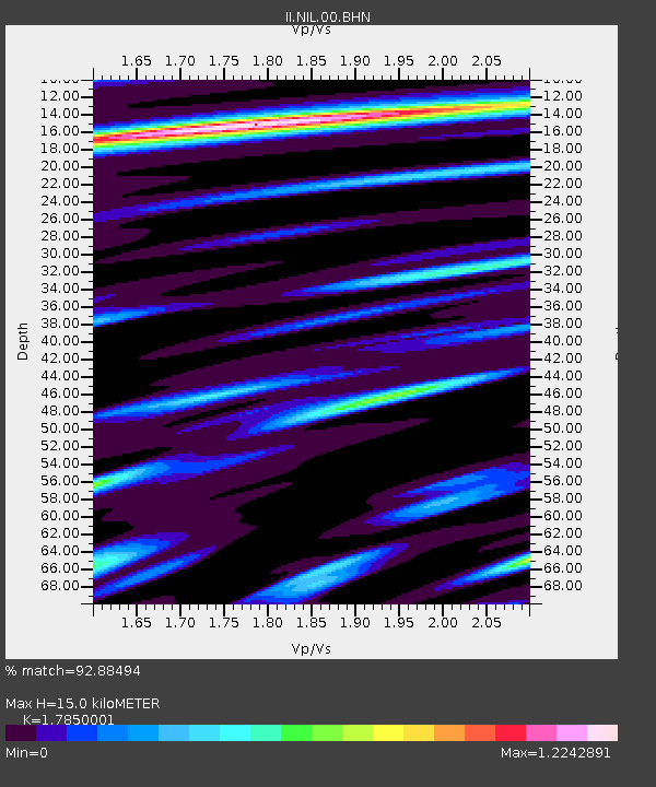
| Estimated Moho Depth: |
15.0 km |
| Estimated Crust Vp/Vs: |
1.79 |
| Assumed Crust Vp: |
6.242 km/s |
| Estimated Crust Vs: |
3.497 km/s |
| Estimated Crust Poisson's Ratio: |
0.27 |
|
| Radial Match: |
92.88494 % |
| Radial Bump: |
400 |
| Transverse Match: |
81.76806 % |
| Transverse Bump: |
400 |
| SOD ConfigId: |
6273 |
| Insert Time: |
2010-03-02 00:25:23.213 +0000 |
| GWidth: |
2.5 |
| Max Bumps: |
400 |
| Tol: |
0.001 |
|
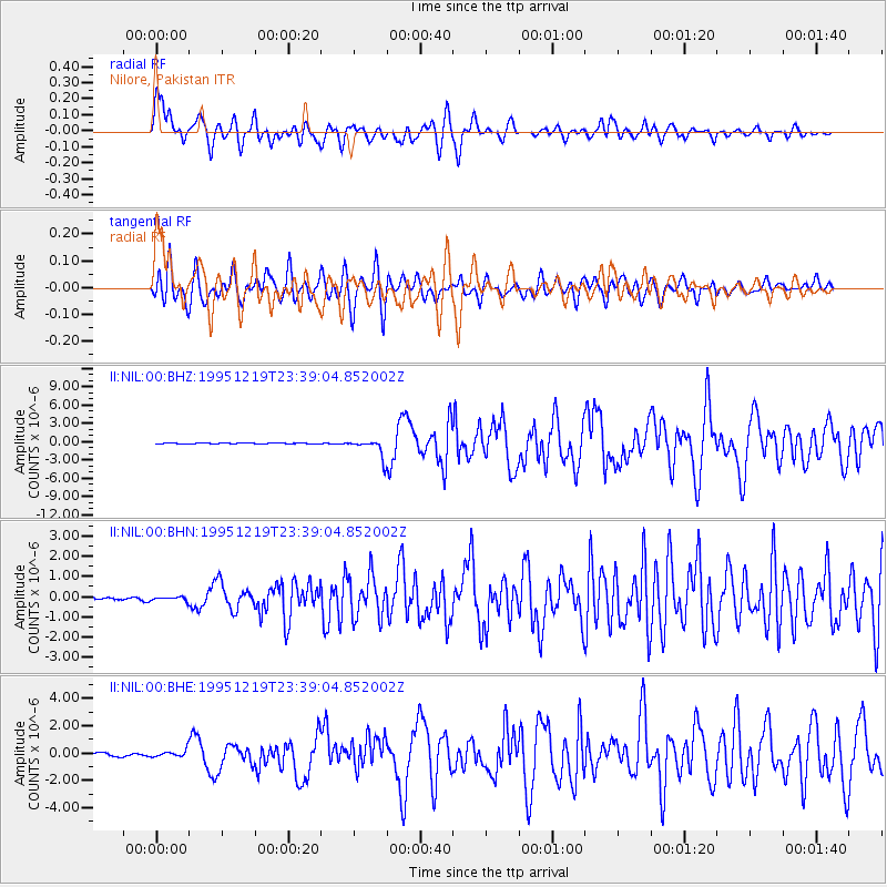
Signal To Noise
| Channel | StoN | STA | LTA |
| II:NIL:00:BHN:19951219T23:39:04.852002Z | 0.85598093 | 9.935008E-8 | 1.1606577E-7 |
| II:NIL:00:BHE:19951219T23:39:04.852002Z | 2.9301045 | 2.6549807E-7 | 9.061045E-8 |
| II:NIL:00:BHZ:19951219T23:39:04.852002Z | 20.40032 | 1.5154737E-6 | 7.428677E-8 |
| Arrivals |
| Ps | 1.9 SECOND |
| PpPs | 6.5 SECOND |
| PsPs/PpSs | 8.4 SECOND |


