NIL Nilore, Pakistan - Earthquake Result Viewer
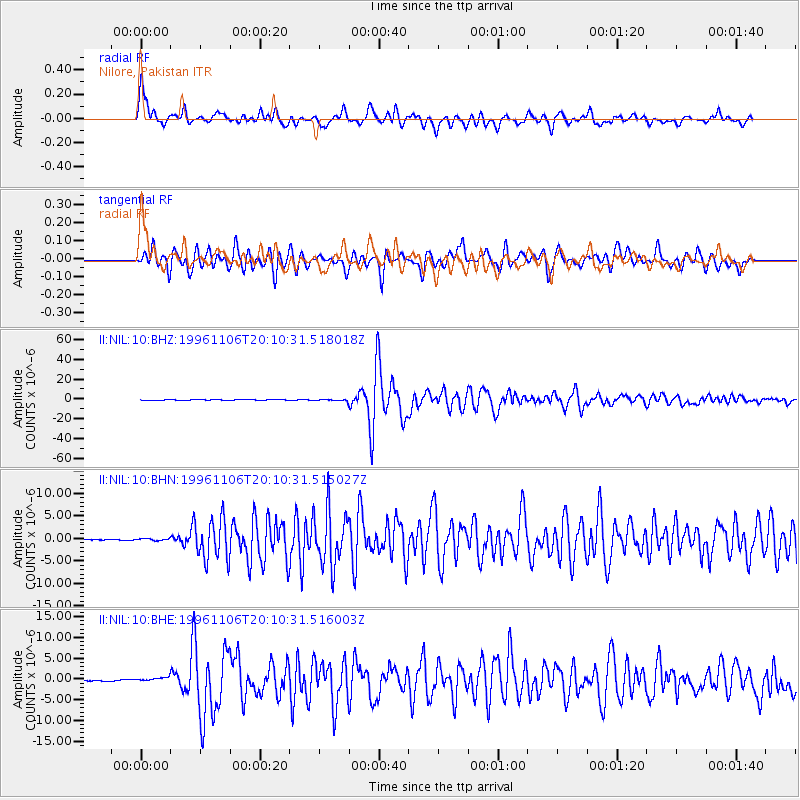
Earthquake location: Bonin Islands, Japan Region
Earthquake latitude/longitude: 28.0/143.5
Earthquake time(UTC): 1996/11/06 (311) 20:00:58 GMT
Earthquake Depth: 9.0 km
Earthquake Magnitude: 6.4 MB, 6.5 MS, 6.6 UNKNOWN, 6.4 ME
Earthquake Catalog/Contributor: WHDF/NEIC
Network: II Global Seismograph Network (GSN - IRIS/IDA)
Station: NIL Nilore, Pakistan
Lat/Lon: 33.65 N/73.27 E
Elevation: 629 m
Distance: 59.6 deg
Az: 294.402 deg
Baz: 74.88 deg
Ray Param: 0.062107757
Estimated Moho Depth: 52.0 km
Estimated Crust Vp/Vs: 1.86
Assumed Crust Vp: 6.242 km/s
Estimated Crust Vs: 3.36 km/s
Estimated Crust Poisson's Ratio: 0.30
Radial Match: 88.46319 %
Radial Bump: 400
Transverse Match: 87.2181 %
Transverse Bump: 400
SOD ConfigId: 6273
Insert Time: 2010-03-02 00:25:29.717 +0000
GWidth: 2.5
Max Bumps: 400
Tol: 0.001

Signal To Noise

ChannelStoNSTALTA
II:NIL:10:BHN:19961106T20:10:31.515027Z1.65316262.212755E-71.3384981E-7
II:NIL:10:BHE:19961106T20:10:31.516003Z2.44340185.609511E-72.2957792E-7
II:NIL:10:BHZ:19961106T20:10:31.518018Z5.8209427.492579E-71.2871763E-7
Arrivals
Ps7.5 SECOND
PpPs23 SECOND
PsPs/PpSs30 SECOND