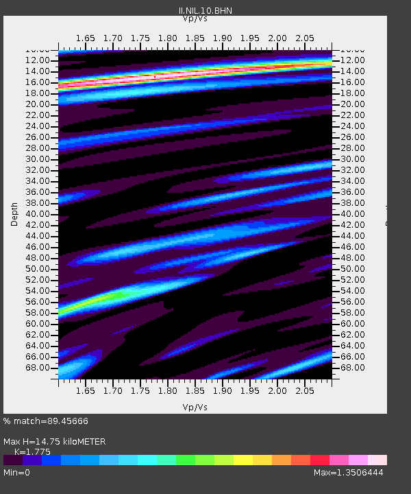
NIL Nilore, Pakistan - Earthquake Result Viewer
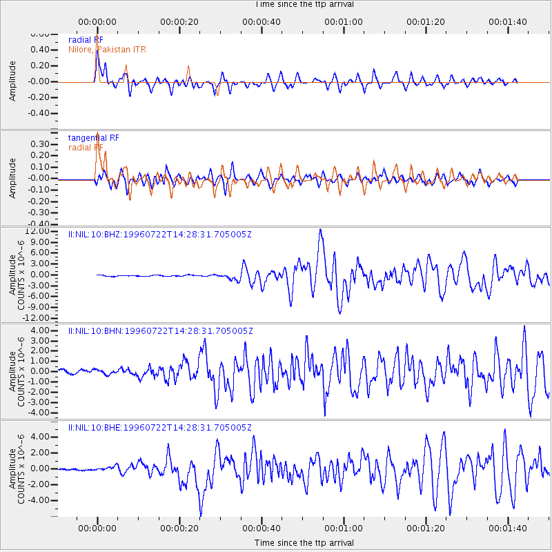
Earthquake location: Minahassa Peninsula, Sulawesi
Earthquake latitude/longitude: 1.0/120.4
Earthquake time(UTC): 1996/07/22 (204) 14:19:35 GMT
Earthquake Depth: 33 km
Earthquake Magnitude: 6.0 MB, 6.9 MS, 7.0 UNKNOWN, 6.9 MW
Earthquake Catalog/Contributor: WHDF/NEIC
Network: II Global Seismograph Network (GSN - IRIS/IDA)
Station: NIL Nilore, Pakistan
Lat/Lon: 33.65 N/73.27 E
Elevation: 629 m
Distance: 54.8 deg
Az: 311.517 deg
Baz: 116.167 deg
Ray Param: 0.06515591
Estimated Moho Depth: 14.75 km
Estimated Crust Vp/Vs: 1.77
Assumed Crust Vp: 6.242 km/s
Estimated Crust Vs: 3.517 km/s
Estimated Crust Poisson's Ratio: 0.27
Radial Match: 89.45666 %
Radial Bump: 400
Transverse Match: 84.24148 %
Transverse Bump: 400
SOD ConfigId: 6273
Insert Time: 2010-03-02 00:25:50.900 +0000
GWidth: 2.5
Max Bumps: 400
Tol: 0.001

Signal To Noise

ChannelStoNSTALTA
II:NIL:10:BHN:19960722T14:28:31.705005Z1.21322192.7020133E-72.2271388E-7
II:NIL:10:BHE:19960722T14:28:31.705005Z2.11365342.97588E-71.4079318E-7
II:NIL:10:BHZ:19960722T14:28:31.705005Z5.8702498.7873036E-71.4969218E-7
Arrivals
Ps1.9 SECOND
PpPs6.2 SECOND
PsPs/PpSs8.2 SECOND