You are here: Home > Network List > II - Global Seismograph Network (GSN - IRIS/IDA) Stations List
> Station NIL Nilore, Pakistan > Earthquake Result Viewer
NIL Nilore, Pakistan - Earthquake Result Viewer
| Earthquake location: |
Kyushu, Japan |
| Earthquake latitude/longitude: |
30.6/131.1 |
| Earthquake time(UTC): |
1996/10/18 (292) 10:50:20 GMT |
| Earthquake Depth: |
10 km |
| Earthquake Magnitude: |
6.0 MB, 6.6 MS, 6.8 UNKNOWN, 6.8 MW |
| Earthquake Catalog/Contributor: |
WHDF/NEIC |
|
| Network: |
II Global Seismograph Network (GSN - IRIS/IDA) |
| Station: |
NIL Nilore, Pakistan |
| Lat/Lon: |
33.65 N/73.27 E |
| Elevation: |
629 m |
|
| Distance: |
48.5 deg |
| Az: |
289.567 deg |
| Baz: |
76.983 deg |
| Ray Param: |
0.069300614 |
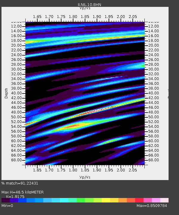
| Estimated Moho Depth: |
46.5 km |
| Estimated Crust Vp/Vs: |
1.92 |
| Assumed Crust Vp: |
6.242 km/s |
| Estimated Crust Vs: |
3.255 km/s |
| Estimated Crust Poisson's Ratio: |
0.31 |
|
| Radial Match: |
91.22431 % |
| Radial Bump: |
400 |
| Transverse Match: |
71.035324 % |
| Transverse Bump: |
400 |
| SOD ConfigId: |
6273 |
| Insert Time: |
2010-03-02 00:25:56.318 +0000 |
| GWidth: |
2.5 |
| Max Bumps: |
400 |
| Tol: |
0.001 |
|
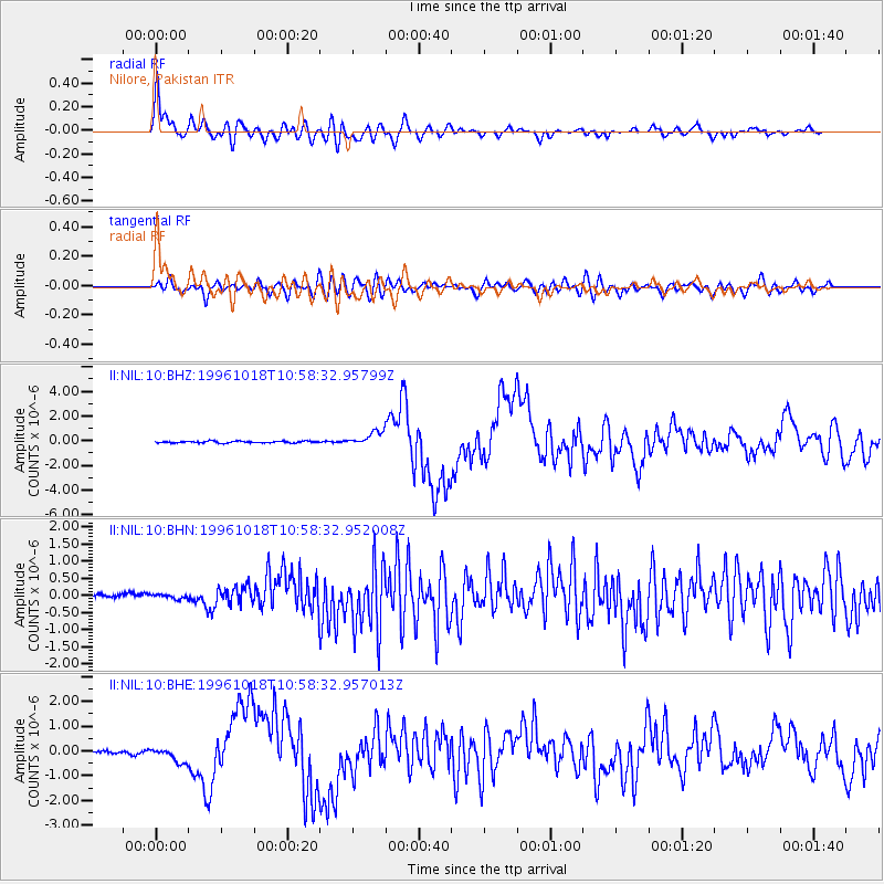
Signal To Noise
| Channel | StoN | STA | LTA |
| II:NIL:10:BHN:19961018T10:58:32.952008Z | 0.6858371 | 6.8320524E-8 | 9.961626E-8 |
| II:NIL:10:BHE:19961018T10:58:32.957013Z | 3.2714446 | 2.9101597E-7 | 8.895641E-8 |
| II:NIL:10:BHZ:19961018T10:58:32.95799Z | 7.9023395 | 5.723716E-7 | 7.243065E-8 |
| Arrivals |
| Ps | 7.2 SECOND |
| PpPs | 21 SECOND |
| PsPs/PpSs | 28 SECOND |


