You are here: Home > Network List > GS - US Geological Survey Networks Stations List
> Station OK028 N Oak Rd and Britton Rd, Lincoln County > Earthquake Result Viewer
OK028 N Oak Rd and Britton Rd, Lincoln County - Earthquake Result Viewer
| Earthquake location: |
Southeastern Alaska |
| Earthquake latitude/longitude: |
58.4/-137.1 |
| Earthquake time(UTC): |
2014/07/25 (206) 10:54:49 GMT |
| Earthquake Depth: |
10 km |
| Earthquake Magnitude: |
5.9 MWP |
| Earthquake Catalog/Contributor: |
NEIC PDE/NEIC COMCAT |
|
| Network: |
GS US Geological Survey Networks |
| Station: |
OK028 N Oak Rd and Britton Rd, Lincoln County |
| Lat/Lon: |
35.56 N/97.06 W |
| Elevation: |
330 m |
|
| Distance: |
34.8 deg |
| Az: |
113.204 deg |
| Baz: |
323.54 deg |
| Ray Param: |
0.07754306 |
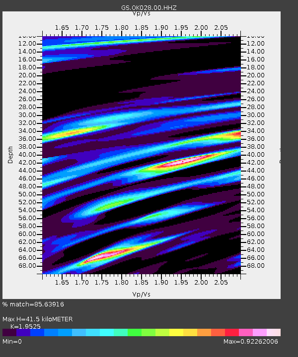
| Estimated Moho Depth: |
41.5 km |
| Estimated Crust Vp/Vs: |
1.95 |
| Assumed Crust Vp: |
6.426 km/s |
| Estimated Crust Vs: |
3.291 km/s |
| Estimated Crust Poisson's Ratio: |
0.32 |
|
| Radial Match: |
85.63916 % |
| Radial Bump: |
328 |
| Transverse Match: |
56.886864 % |
| Transverse Bump: |
400 |
| SOD ConfigId: |
769524 |
| Insert Time: |
2014-08-08 11:17:51.067 +0000 |
| GWidth: |
2.5 |
| Max Bumps: |
400 |
| Tol: |
0.001 |
|

Signal To Noise
| Channel | StoN | STA | LTA |
| GS:OK028:00:HHZ:20140725T11:01:09.938997Z | 5.2874737 | 8.532487E-7 | 1.613717E-7 |
| GS:OK028:00:HH1:20140725T11:01:09.938997Z | 3.3300087 | 5.4812284E-7 | 1.64601E-7 |
| GS:OK028:00:HH2:20140725T11:01:09.938997Z | 1.4041572 | 2.4094132E-7 | 1.7159142E-7 |
| Arrivals |
| Ps | 6.6 SECOND |
| PpPs | 18 SECOND |
| PsPs/PpSs | 24 SECOND |


