You are here: Home > Network List > II - Global Seismograph Network (GSN - IRIS/IDA) Stations List
> Station NIL Nilore, Pakistan > Earthquake Result Viewer
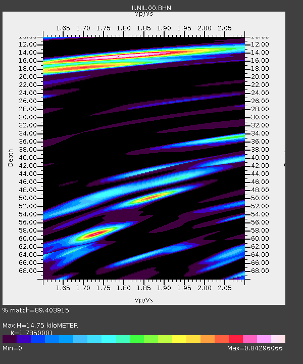
NIL Nilore, Pakistan - Earthquake Result Viewer
| Earthquake location: |
Mindanao, Philippines |
| Earthquake latitude/longitude: |
8.1/126.6 |
| Earthquake time(UTC): |
1997/09/15 (258) 13:05:42 GMT |
| Earthquake Depth: |
51 km |
| Earthquake Magnitude: |
5.8 MB, 5.7 MS, 6.1 UNKNOWN, 6.1 MW |
| Earthquake Catalog/Contributor: |
WHDF/NEIC |
|
| Network: |
II Global Seismograph Network (GSN - IRIS/IDA) |
| Station: |
NIL Nilore, Pakistan |
| Lat/Lon: |
33.65 N/73.27 E |
| Elevation: |
629 m |
|
| Distance: |
55.3 deg |
| Az: |
305.442 deg |
| Baz: |
104.741 deg |
| Ray Param: |
0.06478968 |
| Estimated Moho Depth: |
14.75 km |
| Estimated Crust Vp/Vs: |
1.79 |
| Assumed Crust Vp: |
6.242 km/s |
| Estimated Crust Vs: |
3.497 km/s |
| Estimated Crust Poisson's Ratio: |
0.27 |
|
| Radial Match: |
89.403915 % |
| Radial Bump: |
400 |
| Transverse Match: |
83.67792 % |
| Transverse Bump: |
400 |
| SOD ConfigId: |
6273 |
| Insert Time: |
2010-03-02 00:26:40.994 +0000 |
| GWidth: |
2.5 |
| Max Bumps: |
400 |
| Tol: |
0.001 |
|

Signal To Noise
| Channel | StoN | STA | LTA |
| II:NIL:00:BHN:19970915T13:14:40.114001Z | 0.9984666 | 1.0656871E-7 | 1.0673238E-7 |
| II:NIL:00:BHE:19970915T13:14:40.114001Z | 4.8705444 | 5.377121E-7 | 1.1040081E-7 |
| II:NIL:00:BHZ:19970915T13:14:40.114001Z | 5.3572316 | 1.8312273E-6 | 3.4182344E-7 |
| Arrivals |
| Ps | 1.9 SECOND |
| PpPs | 6.3 SECOND |
| PsPs/PpSs | 8.2 SECOND |


