You are here: Home > Network List > LD - Lamont-Doherty Cooperative Seismographic Network Stations List
> Station LUPA Lehigh University, PA > Earthquake Result Viewer
LUPA Lehigh University, PA - Earthquake Result Viewer
| Earthquake location: |
Southeastern Alaska |
| Earthquake latitude/longitude: |
58.4/-137.1 |
| Earthquake time(UTC): |
2014/07/25 (206) 10:54:49 GMT |
| Earthquake Depth: |
10 km |
| Earthquake Magnitude: |
5.9 MWP |
| Earthquake Catalog/Contributor: |
NEIC PDE/NEIC COMCAT |
|
| Network: |
LD Lamont-Doherty Cooperative Seismographic Network |
| Station: |
LUPA Lehigh University, PA |
| Lat/Lon: |
40.60 N/75.37 W |
| Elevation: |
236 m |
|
| Distance: |
42.2 deg |
| Az: |
86.966 deg |
| Baz: |
316.263 deg |
| Ray Param: |
0.073310465 |
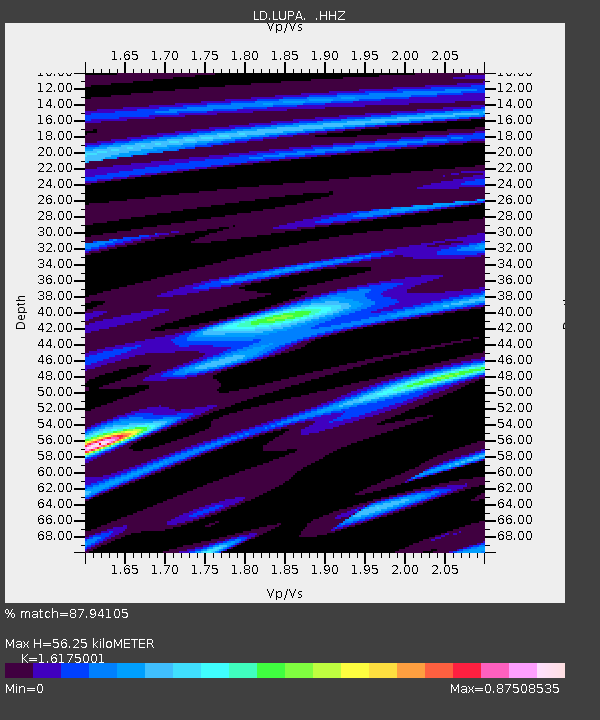
| Estimated Moho Depth: |
56.25 km |
| Estimated Crust Vp/Vs: |
1.62 |
| Assumed Crust Vp: |
6.283 km/s |
| Estimated Crust Vs: |
3.885 km/s |
| Estimated Crust Poisson's Ratio: |
0.19 |
|
| Radial Match: |
87.94105 % |
| Radial Bump: |
295 |
| Transverse Match: |
60.817665 % |
| Transverse Bump: |
329 |
| SOD ConfigId: |
769524 |
| Insert Time: |
2014-08-08 11:26:44.446 +0000 |
| GWidth: |
2.5 |
| Max Bumps: |
400 |
| Tol: |
0.001 |
|

Signal To Noise
| Channel | StoN | STA | LTA |
| LD:LUPA: :HHZ:20140725T11:02:11.825013Z | 7.0272484 | 1.8192269E-7 | 2.5888184E-8 |
| LD:LUPA: :HHN:20140725T11:02:11.825013Z | 3.1379673 | 8.209428E-8 | 2.616161E-8 |
| LD:LUPA: :HHE:20140725T11:02:11.825013Z | 3.1037567 | 8.077231E-8 | 2.6024047E-8 |
| Arrivals |
| Ps | 5.9 SECOND |
| PpPs | 22 SECOND |
| PsPs/PpSs | 28 SECOND |


