You are here: Home > Network List > LD - Lamont-Doherty Cooperative Seismographic Network Stations List
> Station MVL Millersville University, PA > Earthquake Result Viewer
MVL Millersville University, PA - Earthquake Result Viewer

| Earthquake location: |
Southeastern Alaska |
| Earthquake latitude/longitude: |
58.4/-137.1 |
| Earthquake time(UTC): |
2014/07/25 (206) 10:54:49 GMT |
| Earthquake Depth: |
10 km |
| Earthquake Magnitude: |
5.9 MWP |
| Earthquake Catalog/Contributor: |
NEIC PDE/NEIC COMCAT |
|
| Network: |
LD Lamont-Doherty Cooperative Seismographic Network |
| Station: |
MVL Millersville University, PA |
| Lat/Lon: |
40.00 N/76.35 W |
| Elevation: |
91 m |
|
| Distance: |
42.1 deg |
| Az: |
88.389 deg |
| Baz: |
316.687 deg |
| Ray Param: |
0.07335744 |
| Estimated Moho Depth: |
53.25 km |
| Estimated Crust Vp/Vs: |
1.62 |
| Assumed Crust Vp: |
6.419 km/s |
| Estimated Crust Vs: |
3.962 km/s |
| Estimated Crust Poisson's Ratio: |
0.19 |
|
| Radial Match: |
88.81121 % |
| Radial Bump: |
220 |
| Transverse Match: |
57.487804 % |
| Transverse Bump: |
362 |
| SOD ConfigId: |
769524 |
| Insert Time: |
2014-08-08 11:27:24.434 +0000 |
| GWidth: |
2.5 |
| Max Bumps: |
400 |
| Tol: |
0.001 |
|
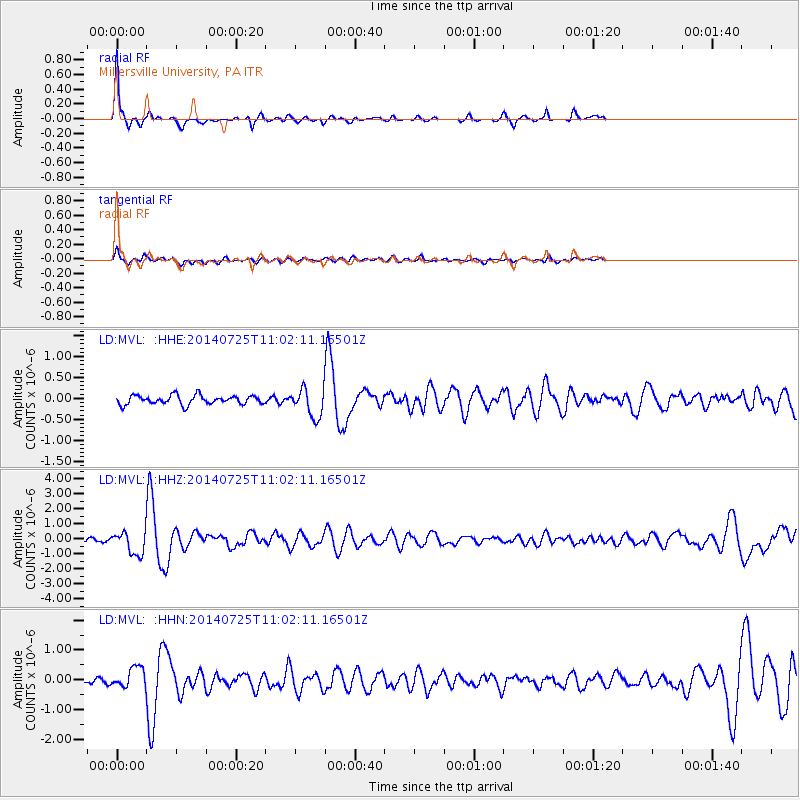
Signal To Noise
| Channel | StoN | STA | LTA |
| LD:MVL: :HHZ:20140725T11:02:11.16501Z | 5.025059 | 7.5121113E-7 | 1.4949299E-7 |
| LD:MVL: :HHN:20140725T11:02:11.16501Z | 3.1087685 | 3.3904837E-7 | 1.09061965E-7 |
| LD:MVL: :HHE:20140725T11:02:11.16501Z | 3.1005545 | 3.3377364E-7 | 1.07649655E-7 |
| Arrivals |
| Ps | 5.5 SECOND |
| PpPs | 20 SECOND |
| PsPs/PpSs | 26 SECOND |


