You are here: Home > Network List > II - Global Seismograph Network (GSN - IRIS/IDA) Stations List
> Station NIL Nilore, Pakistan > Earthquake Result Viewer
NIL Nilore, Pakistan - Earthquake Result Viewer
| Earthquake location: |
Andreanof Islands, Aleutian Is. |
| Earthquake latitude/longitude: |
51.4/-179.0 |
| Earthquake time(UTC): |
2007/12/21 (355) 07:24:34 GMT |
| Earthquake Depth: |
30 km |
| Earthquake Magnitude: |
6.1 MB, 6.2 MW, 6.3 ML |
| Earthquake Catalog/Contributor: |
WHDF/NEIC |
|
| Network: |
II Global Seismograph Network (GSN - IRIS/IDA) |
| Station: |
NIL Nilore, Pakistan |
| Lat/Lon: |
33.65 N/73.27 E |
| Elevation: |
629 m |
|
| Distance: |
74.3 deg |
| Az: |
304.402 deg |
| Baz: |
38.33 deg |
| Ray Param: |
0.05236787 |
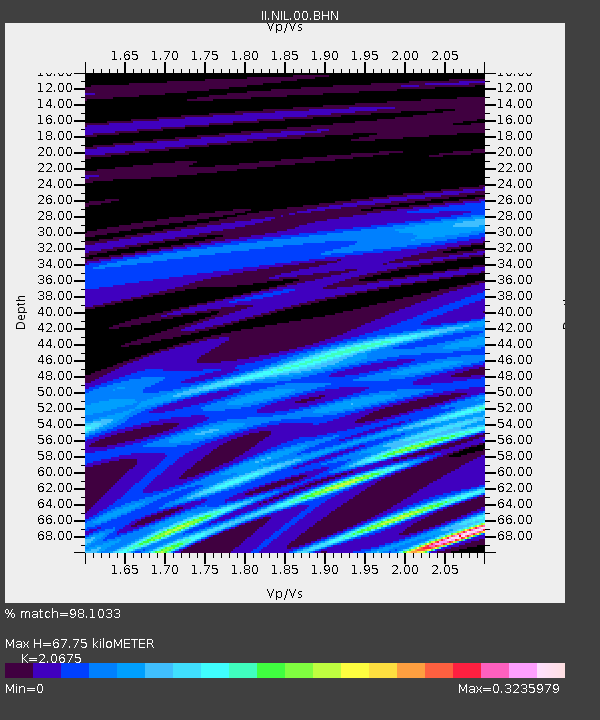
| Estimated Moho Depth: |
67.75 km |
| Estimated Crust Vp/Vs: |
2.07 |
| Assumed Crust Vp: |
6.242 km/s |
| Estimated Crust Vs: |
3.019 km/s |
| Estimated Crust Poisson's Ratio: |
0.35 |
|
| Radial Match: |
98.1033 % |
| Radial Bump: |
87 |
| Transverse Match: |
97.63614 % |
| Transverse Bump: |
90 |
| SOD ConfigId: |
2564 |
| Insert Time: |
2010-03-02 00:26:57.016 +0000 |
| GWidth: |
2.5 |
| Max Bumps: |
400 |
| Tol: |
0.001 |
|

Signal To Noise
| Channel | StoN | STA | LTA |
| II:NIL:00:BHN:20071221T07:35:38.242014Z | 0.90323263 | 2.4215075E-7 | 2.6809343E-7 |
| II:NIL:00:BHE:20071221T07:35:38.242014Z | 2.5884674 | 4.1770906E-7 | 1.6137311E-7 |
| II:NIL:00:BHZ:20071221T07:35:38.242014Z | 1.2876408 | 5.2452815E-8 | 4.0735596E-8 |
| Arrivals |
| Ps | 12 SECOND |
| PpPs | 32 SECOND |
| PsPs/PpSs | 44 SECOND |


