You are here: Home > Network List > CI - Caltech Regional Seismic Network Stations List
> Station NEE Needles, California, USA > Earthquake Result Viewer
NEE Needles, California, USA - Earthquake Result Viewer
| Earthquake location: |
Near Coast Of Peru |
| Earthquake latitude/longitude: |
-16.7/-72.7 |
| Earthquake time(UTC): |
1999/04/03 (093) 06:17:18 GMT |
| Earthquake Depth: |
87 km |
| Earthquake Magnitude: |
6.1 MB, 6.2 MS, 6.8 MW, 6.8 MW |
| Earthquake Catalog/Contributor: |
WHDF/NEIC |
|
| Network: |
CI Caltech Regional Seismic Network |
| Station: |
NEE Needles, California, USA |
| Lat/Lon: |
34.82 N/114.60 W |
| Elevation: |
139 m |
|
| Distance: |
64.9 deg |
| Az: |
322.606 deg |
| Baz: |
134.962 deg |
| Ray Param: |
0.05841754 |
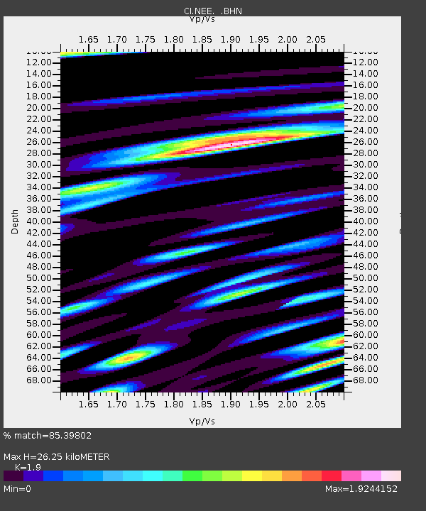
| Estimated Moho Depth: |
26.25 km |
| Estimated Crust Vp/Vs: |
1.90 |
| Assumed Crust Vp: |
6.276 km/s |
| Estimated Crust Vs: |
3.303 km/s |
| Estimated Crust Poisson's Ratio: |
0.31 |
|
| Radial Match: |
85.39802 % |
| Radial Bump: |
400 |
| Transverse Match: |
79.20564 % |
| Transverse Bump: |
400 |
| SOD ConfigId: |
3770 |
| Insert Time: |
2010-02-25 21:12:57.384 +0000 |
| GWidth: |
2.5 |
| Max Bumps: |
400 |
| Tol: |
0.001 |
|

Signal To Noise
| Channel | StoN | STA | LTA |
| CI:NEE: :BHN:19990403T06:27:17.531997Z | 0.907221 | 3.661837E-7 | 4.036323E-7 |
| CI:NEE: :BHE:19990403T06:27:17.531997Z | 1.3226231 | 5.4161643E-7 | 4.095017E-7 |
| CI:NEE: :BHZ:19990403T06:27:17.531997Z | 0.9508261 | 3.842811E-7 | 4.0415495E-7 |
| Arrivals |
| Ps | 3.9 SECOND |
| PpPs | 12 SECOND |
| PsPs/PpSs | 16 SECOND |


