You are here: Home > Network List > N4 - Central and EAstern US Network Stations List
> Station R32B Long Quarter, Great Bend, KS, USA > Earthquake Result Viewer
R32B Long Quarter, Great Bend, KS, USA - Earthquake Result Viewer
| Earthquake location: |
Southeastern Alaska |
| Earthquake latitude/longitude: |
58.4/-137.1 |
| Earthquake time(UTC): |
2014/07/25 (206) 10:54:49 GMT |
| Earthquake Depth: |
10 km |
| Earthquake Magnitude: |
5.9 MWP |
| Earthquake Catalog/Contributor: |
NEIC PDE/NEIC COMCAT |
|
| Network: |
N4 Central and EAstern US Network |
| Station: |
R32B Long Quarter, Great Bend, KS, USA |
| Lat/Lon: |
38.42 N/98.71 W |
| Elevation: |
568 m |
|
| Distance: |
31.8 deg |
| Az: |
111.948 deg |
| Baz: |
321.501 deg |
| Ray Param: |
0.0789435 |
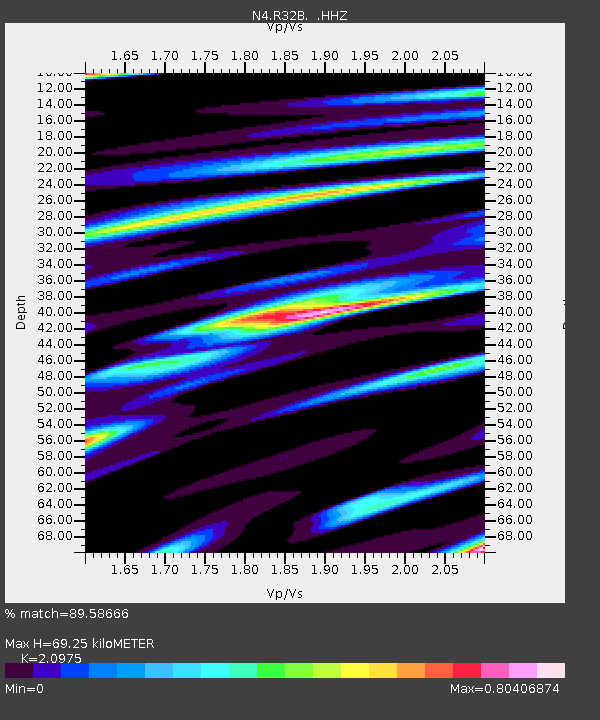
| Estimated Moho Depth: |
69.25 km |
| Estimated Crust Vp/Vs: |
2.10 |
| Assumed Crust Vp: |
6.483 km/s |
| Estimated Crust Vs: |
3.091 km/s |
| Estimated Crust Poisson's Ratio: |
0.35 |
|
| Radial Match: |
89.58666 % |
| Radial Bump: |
268 |
| Transverse Match: |
65.431984 % |
| Transverse Bump: |
400 |
| SOD ConfigId: |
769524 |
| Insert Time: |
2014-08-08 11:32:33.784 +0000 |
| GWidth: |
2.5 |
| Max Bumps: |
400 |
| Tol: |
0.001 |
|

Signal To Noise
| Channel | StoN | STA | LTA |
| N4:R32B: :HHZ:20140725T11:00:43.239991Z | 10.303848 | 7.422785E-7 | 7.203896E-8 |
| N4:R32B: :HHN:20140725T11:00:43.239991Z | 3.611012 | 4.0634035E-7 | 1.12528106E-7 |
| N4:R32B: :HHE:20140725T11:00:43.239991Z | 3.2569005 | 3.486134E-7 | 1.07038396E-7 |
| Arrivals |
| Ps | 13 SECOND |
| PpPs | 31 SECOND |
| PsPs/PpSs | 43 SECOND |


