You are here: Home > Network List > II - Global Seismograph Network (GSN - IRIS/IDA) Stations List
> Station NIL Nilore, Pakistan > Earthquake Result Viewer
NIL Nilore, Pakistan - Earthquake Result Viewer
| Earthquake location: |
Andreanof Islands, Aleutian Is. |
| Earthquake latitude/longitude: |
51.0/-179.3 |
| Earthquake time(UTC): |
2007/12/19 (353) 09:35:16 GMT |
| Earthquake Depth: |
16 km |
| Earthquake Magnitude: |
5.6 MB, 5.5 ML |
| Earthquake Catalog/Contributor: |
WHDF/NEIC |
|
| Network: |
II Global Seismograph Network (GSN - IRIS/IDA) |
| Station: |
NIL Nilore, Pakistan |
| Lat/Lon: |
33.65 N/73.27 E |
| Elevation: |
629 m |
|
| Distance: |
74.3 deg |
| Az: |
304.228 deg |
| Baz: |
38.758 deg |
| Ray Param: |
0.05239994 |
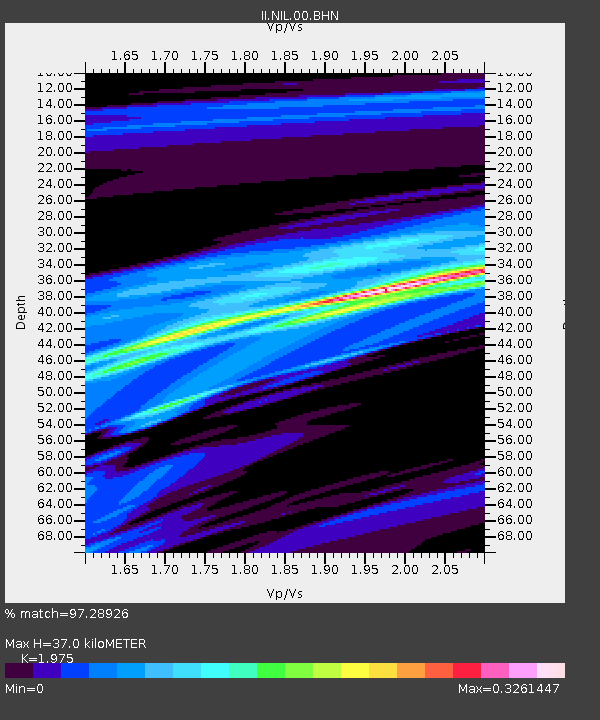
| Estimated Moho Depth: |
37.0 km |
| Estimated Crust Vp/Vs: |
1.98 |
| Assumed Crust Vp: |
6.242 km/s |
| Estimated Crust Vs: |
3.161 km/s |
| Estimated Crust Poisson's Ratio: |
0.33 |
|
| Radial Match: |
97.28926 % |
| Radial Bump: |
92 |
| Transverse Match: |
94.685234 % |
| Transverse Bump: |
114 |
| SOD ConfigId: |
2564 |
| Insert Time: |
2010-03-02 00:27:04.403 +0000 |
| GWidth: |
2.5 |
| Max Bumps: |
400 |
| Tol: |
0.001 |
|
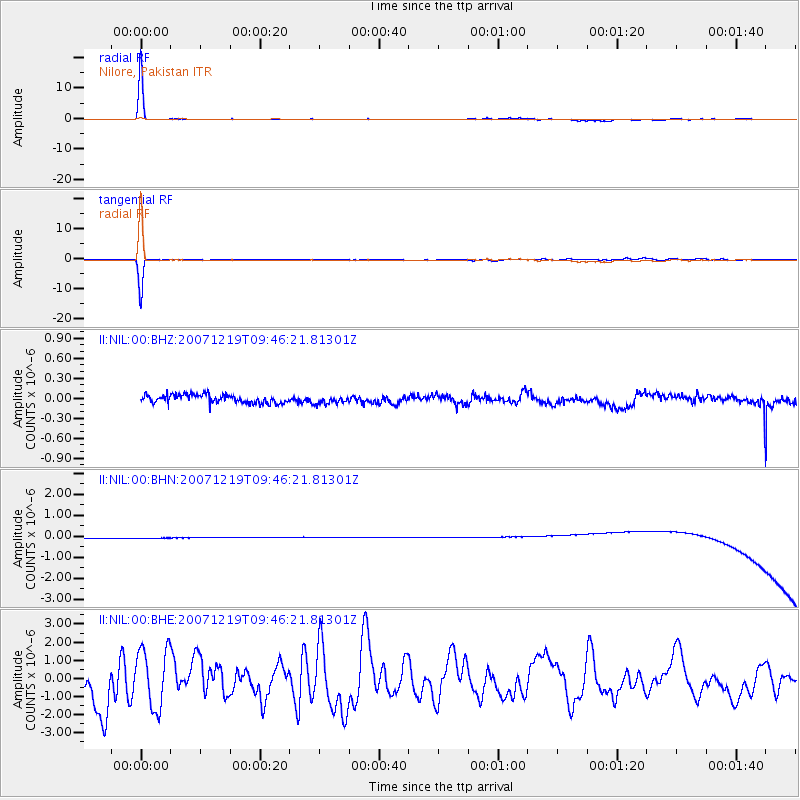
Signal To Noise
| Channel | StoN | STA | LTA |
| II:NIL:00:BHN:20071219T09:46:21.81301Z | 0.91234785 | 2.4466914E-7 | 2.6817526E-7 |
| II:NIL:00:BHE:20071219T09:46:21.81301Z | 1.4331375 | 1.6500693E-6 | 1.1513685E-6 |
| II:NIL:00:BHZ:20071219T09:46:21.81301Z | 0.9732859 | 6.178669E-8 | 6.3482574E-8 |
| Arrivals |
| Ps | 5.9 SECOND |
| PpPs | 17 SECOND |
| PsPs/PpSs | 23 SECOND |


