You are here: Home > Network List > NM - Cooperative New Madrid Seismic Network Stations List
> Station HICK Hickman,KY > Earthquake Result Viewer
HICK Hickman,KY - Earthquake Result Viewer
| Earthquake location: |
Southeastern Alaska |
| Earthquake latitude/longitude: |
58.4/-137.1 |
| Earthquake time(UTC): |
2014/07/25 (206) 10:54:49 GMT |
| Earthquake Depth: |
10 km |
| Earthquake Magnitude: |
5.9 MWP |
| Earthquake Catalog/Contributor: |
NEIC PDE/NEIC COMCAT |
|
| Network: |
NM Cooperative New Madrid Seismic Network |
| Station: |
HICK Hickman,KY |
| Lat/Lon: |
36.54 N/89.23 W |
| Elevation: |
141 m |
|
| Distance: |
38.0 deg |
| Az: |
103.756 deg |
| Baz: |
320.52 deg |
| Ray Param: |
0.07583472 |
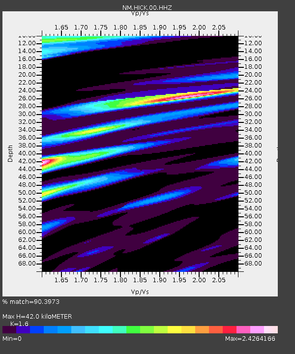
| Estimated Moho Depth: |
42.0 km |
| Estimated Crust Vp/Vs: |
1.60 |
| Assumed Crust Vp: |
6.444 km/s |
| Estimated Crust Vs: |
4.027 km/s |
| Estimated Crust Poisson's Ratio: |
0.18 |
|
| Radial Match: |
90.3973 % |
| Radial Bump: |
285 |
| Transverse Match: |
65.82051 % |
| Transverse Bump: |
400 |
| SOD ConfigId: |
769524 |
| Insert Time: |
2014-08-08 11:38:48.035 +0000 |
| GWidth: |
2.5 |
| Max Bumps: |
400 |
| Tol: |
0.001 |
|

Signal To Noise
| Channel | StoN | STA | LTA |
| NM:HICK:00:HHZ:20140725T11:01:36.725007Z | 9.557719 | 1.9373167E-6 | 2.0269654E-7 |
| NM:HICK:00:HHN:20140725T11:01:36.725007Z | 2.3983877 | 1.1080427E-6 | 4.6199483E-7 |
| NM:HICK:00:HHE:20140725T11:01:36.725007Z | 1.9484682 | 1.4001452E-6 | 7.185876E-7 |
| Arrivals |
| Ps | 4.2 SECOND |
| PpPs | 16 SECOND |
| PsPs/PpSs | 20 SECOND |


