You are here: Home > Network List > PE - Penn State Network Stations List
> Station WRPS We R Penn State > Earthquake Result Viewer
WRPS We R Penn State - Earthquake Result Viewer
| Earthquake location: |
Southeastern Alaska |
| Earthquake latitude/longitude: |
58.4/-137.1 |
| Earthquake time(UTC): |
2014/07/25 (206) 10:54:49 GMT |
| Earthquake Depth: |
10 km |
| Earthquake Magnitude: |
5.9 MWP |
| Earthquake Catalog/Contributor: |
NEIC PDE/NEIC COMCAT |
|
| Network: |
PE Penn State Network |
| Station: |
WRPS We R Penn State |
| Lat/Lon: |
40.79 N/77.87 W |
| Elevation: |
320 m |
|
| Distance: |
40.7 deg |
| Az: |
88.826 deg |
| Baz: |
316.037 deg |
| Ray Param: |
0.07421904 |
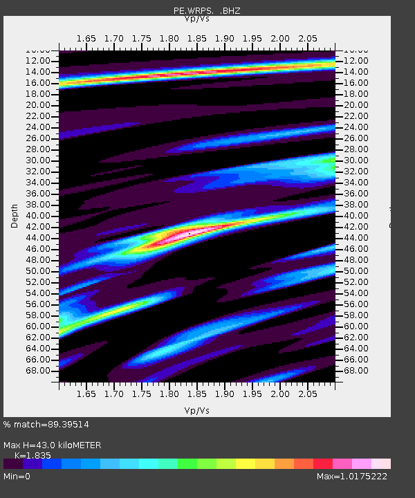
| Estimated Moho Depth: |
43.0 km |
| Estimated Crust Vp/Vs: |
1.84 |
| Assumed Crust Vp: |
6.121 km/s |
| Estimated Crust Vs: |
3.335 km/s |
| Estimated Crust Poisson's Ratio: |
0.29 |
|
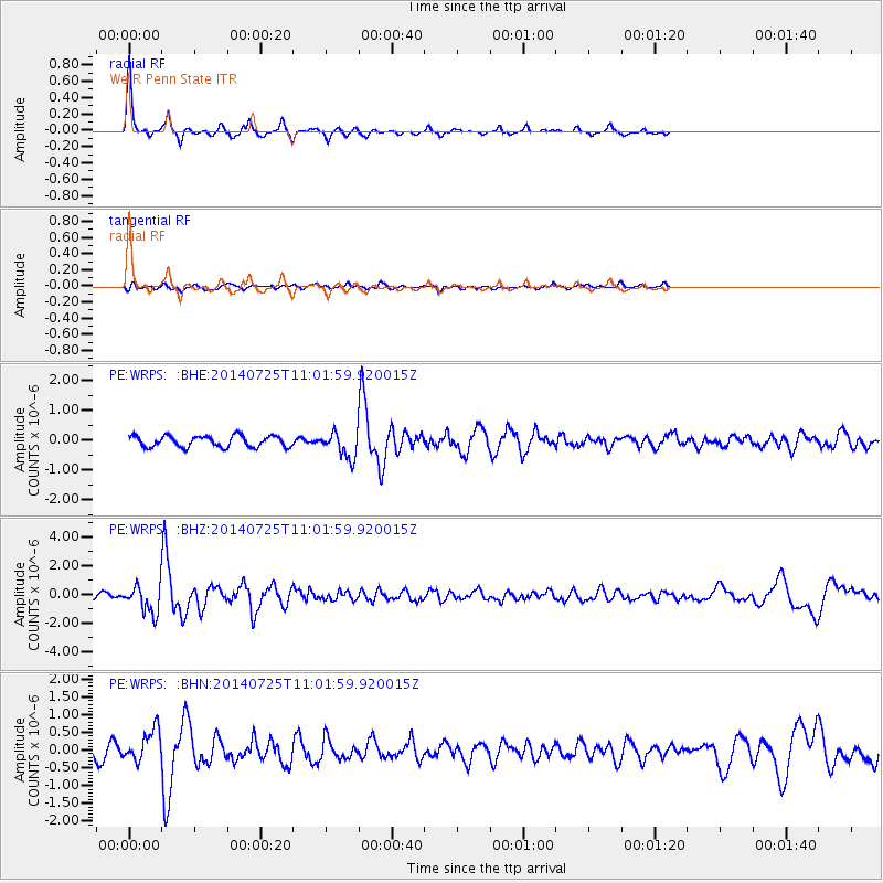
| Radial Match: |
89.39514 % |
| Radial Bump: |
284 |
| Transverse Match: |
59.456787 % |
| Transverse Bump: |
395 |
| SOD ConfigId: |
769524 |
| Insert Time: |
2014-08-08 11:41:11.992 +0000 |
| GWidth: |
2.5 |
| Max Bumps: |
400 |
| Tol: |
0.001 |
|
Signal To Noise
| Channel | StoN | STA | LTA |
| PE:WRPS: :BHZ:20140725T11:01:59.920015Z | 4.6984735 | 9.562543E-7 | 2.0352448E-7 |
| PE:WRPS: :BHN:20140725T11:01:59.920015Z | 2.4686813 | 4.4142783E-7 | 1.7881118E-7 |
| PE:WRPS: :BHE:20140725T11:01:59.920015Z | 2.310115 | 4.3168308E-7 | 1.8686649E-7 |
| Arrivals |
| Ps | 6.2 SECOND |
| PpPs | 19 SECOND |
| PsPs/PpSs | 25 SECOND |


