You are here: Home > Network List > II - Global Seismograph Network (GSN - IRIS/IDA) Stations List
> Station NIL Nilore, Pakistan > Earthquake Result Viewer
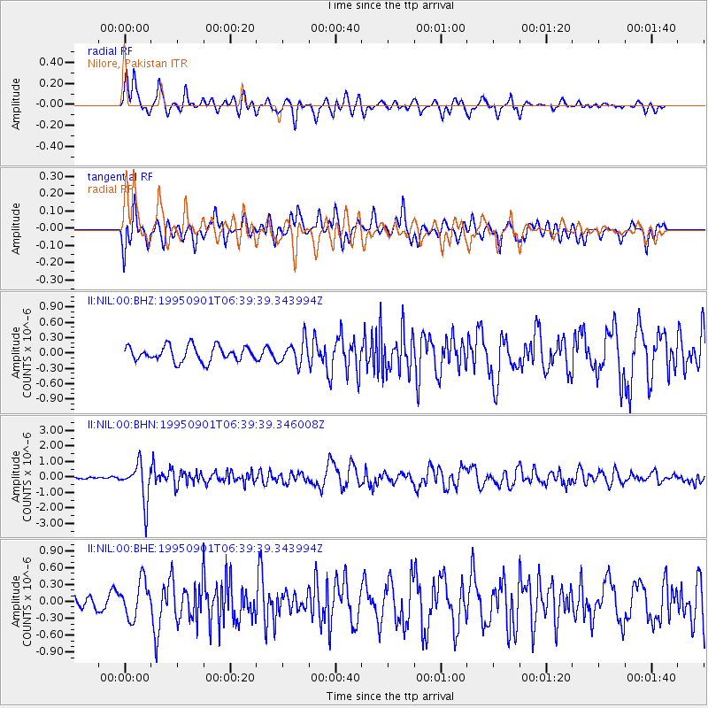
NIL Nilore, Pakistan - Earthquake Result Viewer
*The percent match for this event was below the threshold and hence no stack was calculated.
| Earthquake location: |
Minahassa Peninsula, Sulawesi |
| Earthquake latitude/longitude: |
0.0/123.2 |
| Earthquake time(UTC): |
1995/09/01 (244) 06:30:37 GMT |
| Earthquake Depth: |
163 km |
| Earthquake Magnitude: |
5.5 MB |
| Earthquake Catalog/Contributor: |
WHDF/NEIC |
|
| Network: |
II Global Seismograph Network (GSN - IRIS/IDA) |
| Station: |
NIL Nilore, Pakistan |
| Lat/Lon: |
33.65 N/73.27 E |
| Elevation: |
629 m |
|
| Distance: |
57.6 deg |
| Az: |
310.807 deg |
| Baz: |
114.85 deg |
| Ray Param: |
$rayparam |
*The percent match for this event was below the threshold and hence was not used in the summary stack. |
|
| Radial Match: |
72.270226 % |
| Radial Bump: |
400 |
| Transverse Match: |
66.13742 % |
| Transverse Bump: |
400 |
| SOD ConfigId: |
4480 |
| Insert Time: |
2010-03-02 00:27:30.253 +0000 |
| GWidth: |
2.5 |
| Max Bumps: |
400 |
| Tol: |
0.001 |
|
Signal To Noise
| Channel | StoN | STA | LTA |
| II:NIL:00:BHN:19950901T06:39:39.346008Z | 10.626877 | 1.2381707E-6 | 1.1651313E-7 |
| II:NIL:00:BHE:19950901T06:39:39.343994Z | 1.4918026 | 3.275353E-7 | 2.1955674E-7 |
| II:NIL:00:BHZ:19950901T06:39:39.343994Z | 1.5768346 | 2.3022021E-7 | 1.460015E-7 |
| Arrivals |
| Ps | |
| PpPs | |
| PsPs/PpSs | |


