You are here: Home > Network List > TA - USArray Transportable Network (new EarthScope stations) Stations List
> Station E58A La Victoria, QC, CAN > Earthquake Result Viewer
E58A La Victoria, QC, CAN - Earthquake Result Viewer

| Earthquake location: |
Southeastern Alaska |
| Earthquake latitude/longitude: |
58.4/-137.1 |
| Earthquake time(UTC): |
2014/07/25 (206) 10:54:49 GMT |
| Earthquake Depth: |
10 km |
| Earthquake Magnitude: |
5.9 MWP |
| Earthquake Catalog/Contributor: |
NEIC PDE/NEIC COMCAT |
|
| Network: |
TA USArray Transportable Network (new EarthScope stations) |
| Station: |
E58A La Victoria, QC, CAN |
| Lat/Lon: |
46.37 N/73.28 W |
| Elevation: |
233 m |
|
| Distance: |
39.3 deg |
| Az: |
78.977 deg |
| Baz: |
311.642 deg |
| Ray Param: |
0.07507066 |
| Estimated Moho Depth: |
41.25 km |
| Estimated Crust Vp/Vs: |
1.60 |
| Assumed Crust Vp: |
6.61 km/s |
| Estimated Crust Vs: |
4.131 km/s |
| Estimated Crust Poisson's Ratio: |
0.18 |
|
| Radial Match: |
85.886406 % |
| Radial Bump: |
215 |
| Transverse Match: |
46.9884 % |
| Transverse Bump: |
357 |
| SOD ConfigId: |
769524 |
| Insert Time: |
2014-08-08 11:46:23.176 +0000 |
| GWidth: |
2.5 |
| Max Bumps: |
400 |
| Tol: |
0.001 |
|
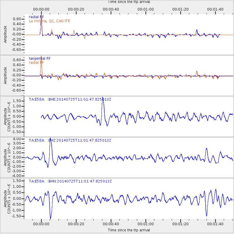
Signal To Noise
| Channel | StoN | STA | LTA |
| TA:E58A: :BHZ:20140725T11:01:47.825013Z | 4.2323475 | 1.0171757E-6 | 2.403337E-7 |
| TA:E58A: :BHN:20140725T11:01:47.825013Z | 2.0515726 | 3.7805384E-7 | 1.8427515E-7 |
| TA:E58A: :BHE:20140725T11:01:47.825013Z | 2.2534318 | 3.6982038E-7 | 1.6411428E-7 |
| Arrivals |
| Ps | 4.1 SECOND |
| PpPs | 15 SECOND |
| PsPs/PpSs | 19 SECOND |


