You are here: Home > Network List > TA - USArray Transportable Network (new EarthScope stations) Stations List
> Station E62A Clayton Lake, ME, USA > Earthquake Result Viewer
E62A Clayton Lake, ME, USA - Earthquake Result Viewer
| Earthquake location: |
Southeastern Alaska |
| Earthquake latitude/longitude: |
58.4/-137.1 |
| Earthquake time(UTC): |
2014/07/25 (206) 10:54:49 GMT |
| Earthquake Depth: |
10 km |
| Earthquake Magnitude: |
5.9 MWP |
| Earthquake Catalog/Contributor: |
NEIC PDE/NEIC COMCAT |
|
| Network: |
TA USArray Transportable Network (new EarthScope stations) |
| Station: |
E62A Clayton Lake, ME, USA |
| Lat/Lon: |
46.62 N/69.52 W |
| Elevation: |
356 m |
|
| Distance: |
41.1 deg |
| Az: |
76.007 deg |
| Baz: |
312.087 deg |
| Ray Param: |
0.074031465 |
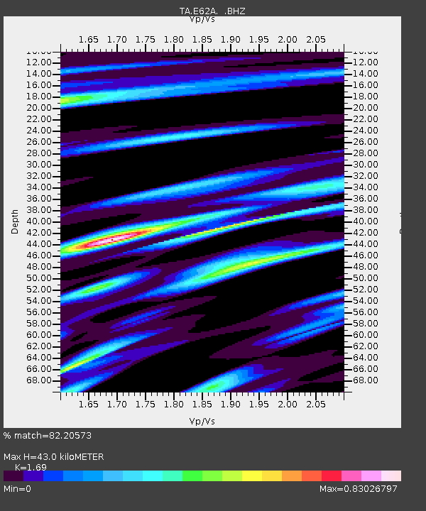
| Estimated Moho Depth: |
43.0 km |
| Estimated Crust Vp/Vs: |
1.69 |
| Assumed Crust Vp: |
6.419 km/s |
| Estimated Crust Vs: |
3.798 km/s |
| Estimated Crust Poisson's Ratio: |
0.23 |
|
| Radial Match: |
82.20573 % |
| Radial Bump: |
400 |
| Transverse Match: |
78.27565 % |
| Transverse Bump: |
400 |
| SOD ConfigId: |
769524 |
| Insert Time: |
2014-08-08 11:46:38.210 +0000 |
| GWidth: |
2.5 |
| Max Bumps: |
400 |
| Tol: |
0.001 |
|

Signal To Noise
| Channel | StoN | STA | LTA |
| TA:E62A: :BHZ:20140725T11:02:02.450013Z | 4.928686 | 1.0529757E-6 | 2.1364227E-7 |
| TA:E62A: :BHN:20140725T11:02:02.450013Z | 3.3782167 | 5.0900314E-7 | 1.5067214E-7 |
| TA:E62A: :BHE:20140725T11:02:02.450013Z | 2.612485 | 6.3188986E-7 | 2.4187312E-7 |
| Arrivals |
| Ps | 5.0 SECOND |
| PpPs | 17 SECOND |
| PsPs/PpSs | 22 SECOND |


