You are here: Home > Network List > TA - USArray Transportable Network (new EarthScope stations) Stations List
> Station H52A Wyevale, ON, CAN > Earthquake Result Viewer
H52A Wyevale, ON, CAN - Earthquake Result Viewer

| Earthquake location: |
Southeastern Alaska |
| Earthquake latitude/longitude: |
58.4/-137.1 |
| Earthquake time(UTC): |
2014/07/25 (206) 10:54:49 GMT |
| Earthquake Depth: |
10 km |
| Earthquake Magnitude: |
5.9 MWP |
| Earthquake Catalog/Contributor: |
NEIC PDE/NEIC COMCAT |
|
| Network: |
TA USArray Transportable Network (new EarthScope stations) |
| Station: |
H52A Wyevale, ON, CAN |
| Lat/Lon: |
44.64 N/79.89 W |
| Elevation: |
209 m |
|
| Distance: |
37.0 deg |
| Az: |
86.1 deg |
| Baz: |
312.544 deg |
| Ray Param: |
0.07637811 |
| Estimated Moho Depth: |
11.0 km |
| Estimated Crust Vp/Vs: |
2.00 |
| Assumed Crust Vp: |
6.577 km/s |
| Estimated Crust Vs: |
3.293 km/s |
| Estimated Crust Poisson's Ratio: |
0.33 |
|
| Radial Match: |
86.23231 % |
| Radial Bump: |
400 |
| Transverse Match: |
70.35315 % |
| Transverse Bump: |
400 |
| SOD ConfigId: |
769524 |
| Insert Time: |
2014-08-08 11:48:44.269 +0000 |
| GWidth: |
2.5 |
| Max Bumps: |
400 |
| Tol: |
0.001 |
|
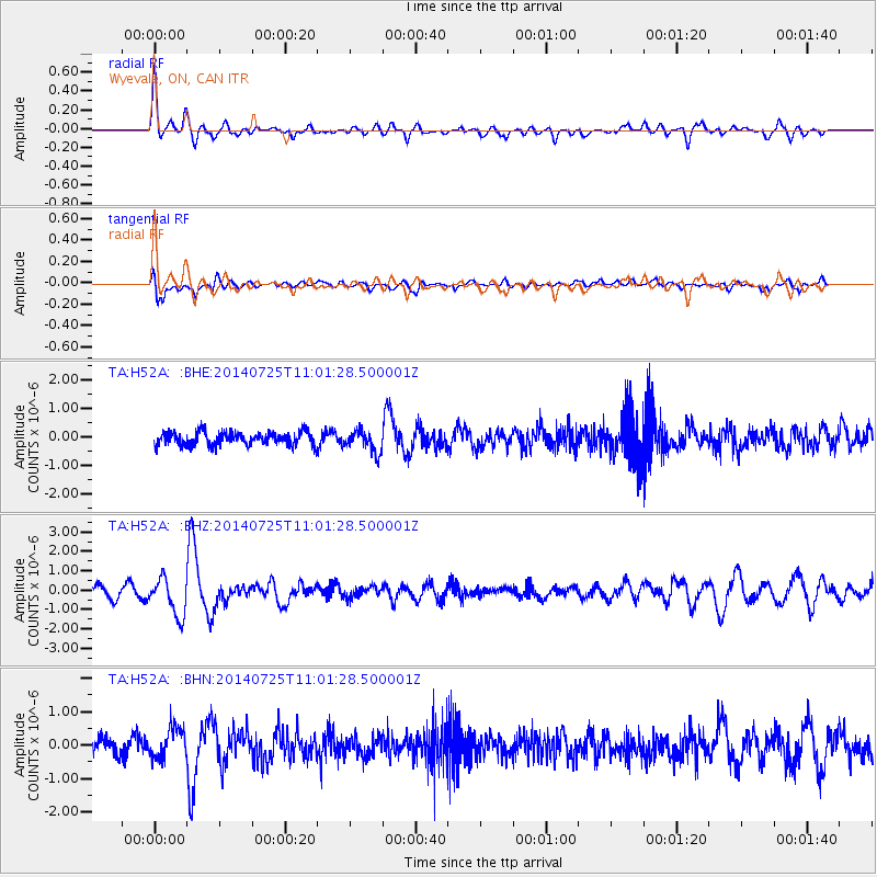
Signal To Noise
| Channel | StoN | STA | LTA |
| TA:H52A: :BHZ:20140725T11:01:28.500001Z | 3.5994768 | 9.697887E-7 | 2.694249E-7 |
| TA:H52A: :BHN:20140725T11:01:28.500001Z | 2.2049608 | 4.6637453E-7 | 2.1151149E-7 |
| TA:H52A: :BHE:20140725T11:01:28.500001Z | 1.6289086 | 3.7782942E-7 | 2.3195248E-7 |
| Arrivals |
| Ps | 1.8 SECOND |
| PpPs | 4.7 SECOND |
| PsPs/PpSs | 6.5 SECOND |


