You are here: Home > Network List > TA - USArray Transportable Network (new EarthScope stations) Stations List
> Station J57A Williamstown, NY, USA > Earthquake Result Viewer
J57A Williamstown, NY, USA - Earthquake Result Viewer
| Earthquake location: |
Southeastern Alaska |
| Earthquake latitude/longitude: |
58.4/-137.1 |
| Earthquake time(UTC): |
2014/07/25 (206) 10:54:49 GMT |
| Earthquake Depth: |
10 km |
| Earthquake Magnitude: |
5.9 MWP |
| Earthquake Catalog/Contributor: |
NEIC PDE/NEIC COMCAT |
|
| Network: |
TA USArray Transportable Network (new EarthScope stations) |
| Station: |
J57A Williamstown, NY, USA |
| Lat/Lon: |
43.41 N/76.00 W |
| Elevation: |
191 m |
|
| Distance: |
39.9 deg |
| Az: |
84.449 deg |
| Baz: |
313.947 deg |
| Ray Param: |
0.074722975 |
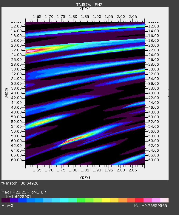
| Estimated Moho Depth: |
22.25 km |
| Estimated Crust Vp/Vs: |
1.60 |
| Assumed Crust Vp: |
6.419 km/s |
| Estimated Crust Vs: |
4.006 km/s |
| Estimated Crust Poisson's Ratio: |
0.18 |
|
| Radial Match: |
80.64926 % |
| Radial Bump: |
342 |
| Transverse Match: |
60.3471 % |
| Transverse Bump: |
400 |
| SOD ConfigId: |
769524 |
| Insert Time: |
2014-08-08 11:50:54.005 +0000 |
| GWidth: |
2.5 |
| Max Bumps: |
400 |
| Tol: |
0.001 |
|

Signal To Noise
| Channel | StoN | STA | LTA |
| TA:J57A: :BHZ:20140725T11:01:52.774995Z | 5.456932 | 9.124166E-7 | 1.6720321E-7 |
| TA:J57A: :BHN:20140725T11:01:52.774995Z | 2.273795 | 3.0162383E-7 | 1.3265216E-7 |
| TA:J57A: :BHE:20140725T11:01:52.774995Z | 1.6019063 | 2.917113E-7 | 1.821026E-7 |
| Arrivals |
| Ps | 2.3 SECOND |
| PpPs | 8.3 SECOND |
| PsPs/PpSs | 11 SECOND |


