You are here: Home > Network List > TA - USArray Transportable Network (new EarthScope stations) Stations List
> Station J63A Strafford, NH, USA > Earthquake Result Viewer
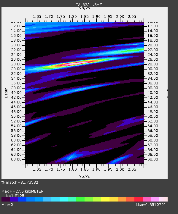
J63A Strafford, NH, USA - Earthquake Result Viewer
| Earthquake location: |
Southeastern Alaska |
| Earthquake latitude/longitude: |
58.4/-137.1 |
| Earthquake time(UTC): |
2014/07/25 (206) 10:54:49 GMT |
| Earthquake Depth: |
10 km |
| Earthquake Magnitude: |
5.9 MWP |
| Earthquake Catalog/Contributor: |
NEIC PDE/NEIC COMCAT |
|
| Network: |
TA USArray Transportable Network (new EarthScope stations) |
| Station: |
J63A Strafford, NH, USA |
| Lat/Lon: |
43.28 N/71.08 W |
| Elevation: |
142 m |
|
| Distance: |
42.5 deg |
| Az: |
80.791 deg |
| Baz: |
314.559 deg |
| Ray Param: |
0.073113605 |
| Estimated Moho Depth: |
27.5 km |
| Estimated Crust Vp/Vs: |
1.81 |
| Assumed Crust Vp: |
6.419 km/s |
| Estimated Crust Vs: |
3.542 km/s |
| Estimated Crust Poisson's Ratio: |
0.28 |
|
| Radial Match: |
81.73532 % |
| Radial Bump: |
375 |
| Transverse Match: |
48.931076 % |
| Transverse Bump: |
355 |
| SOD ConfigId: |
769524 |
| Insert Time: |
2014-08-08 11:51:21.782 +0000 |
| GWidth: |
2.5 |
| Max Bumps: |
400 |
| Tol: |
0.001 |
|

Signal To Noise
| Channel | StoN | STA | LTA |
| TA:J63A: :BHZ:20140725T11:02:14.625001Z | 3.7863262 | 6.011582E-7 | 1.5877085E-7 |
| TA:J63A: :BHN:20140725T11:02:14.625001Z | 2.0694082 | 2.9541724E-7 | 1.4275446E-7 |
| TA:J63A: :BHE:20140725T11:02:14.625001Z | 1.7929231 | 3.690746E-7 | 2.0585077E-7 |
| Arrivals |
| Ps | 3.7 SECOND |
| PpPs | 11 SECOND |
| PsPs/PpSs | 15 SECOND |


