You are here: Home > Network List > TA - USArray Transportable Network (new EarthScope stations) Stations List
> Station K58A Earlville, NY, USA > Earthquake Result Viewer
K58A Earlville, NY, USA - Earthquake Result Viewer
| Earthquake location: |
Southeastern Alaska |
| Earthquake latitude/longitude: |
58.4/-137.1 |
| Earthquake time(UTC): |
2014/07/25 (206) 10:54:49 GMT |
| Earthquake Depth: |
10 km |
| Earthquake Magnitude: |
5.9 MWP |
| Earthquake Catalog/Contributor: |
NEIC PDE/NEIC COMCAT |
|
| Network: |
TA USArray Transportable Network (new EarthScope stations) |
| Station: |
K58A Earlville, NY, USA |
| Lat/Lon: |
42.76 N/75.65 W |
| Elevation: |
509 m |
|
| Distance: |
40.5 deg |
| Az: |
84.89 deg |
| Baz: |
314.521 deg |
| Ray Param: |
0.07435622 |
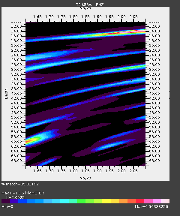
| Estimated Moho Depth: |
13.5 km |
| Estimated Crust Vp/Vs: |
2.09 |
| Assumed Crust Vp: |
6.419 km/s |
| Estimated Crust Vs: |
3.068 km/s |
| Estimated Crust Poisson's Ratio: |
0.35 |
|
| Radial Match: |
85.01192 % |
| Radial Bump: |
324 |
| Transverse Match: |
65.411865 % |
| Transverse Bump: |
400 |
| SOD ConfigId: |
769524 |
| Insert Time: |
2014-08-08 11:51:51.414 +0000 |
| GWidth: |
2.5 |
| Max Bumps: |
400 |
| Tol: |
0.001 |
|
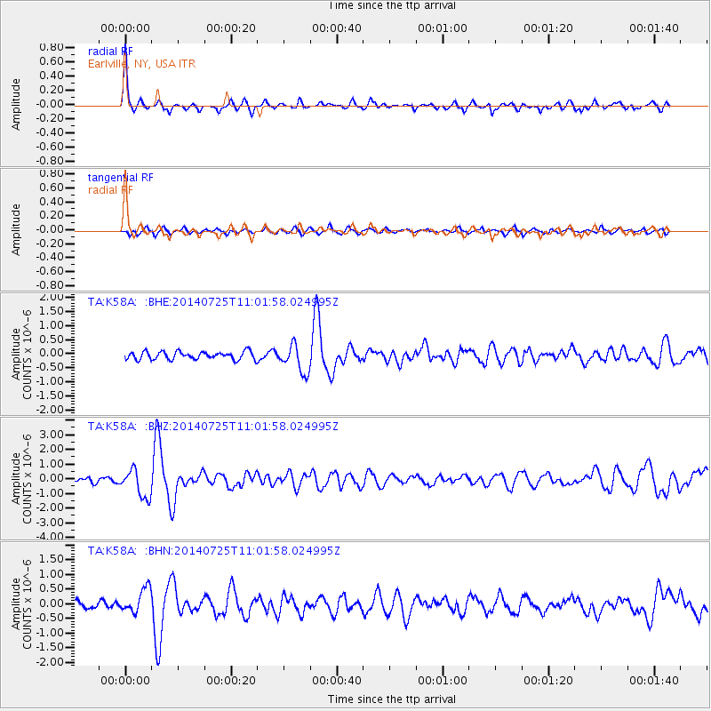
Signal To Noise
| Channel | StoN | STA | LTA |
| TA:K58A: :BHZ:20140725T11:01:58.024995Z | 4.4363794 | 9.573713E-7 | 2.1580014E-7 |
| TA:K58A: :BHN:20140725T11:01:58.024995Z | 2.5079117 | 4.2541805E-7 | 1.6963038E-7 |
| TA:K58A: :BHE:20140725T11:01:58.024995Z | 3.602031 | 5.004177E-7 | 1.3892652E-7 |
| Arrivals |
| Ps | 2.4 SECOND |
| PpPs | 6.1 SECOND |
| PsPs/PpSs | 8.6 SECOND |


