You are here: Home > Network List > TA - USArray Transportable Network (new EarthScope stations) Stations List
> Station M52A Chesterland, OH, USA > Earthquake Result Viewer
M52A Chesterland, OH, USA - Earthquake Result Viewer

| Earthquake location: |
Southeastern Alaska |
| Earthquake latitude/longitude: |
58.4/-137.1 |
| Earthquake time(UTC): |
2014/07/25 (206) 10:54:49 GMT |
| Earthquake Depth: |
10 km |
| Earthquake Magnitude: |
5.9 MWP |
| Earthquake Catalog/Contributor: |
NEIC PDE/NEIC COMCAT |
|
| Network: |
TA USArray Transportable Network (new EarthScope stations) |
| Station: |
M52A Chesterland, OH, USA |
| Lat/Lon: |
41.54 N/81.36 W |
| Elevation: |
382 m |
|
| Distance: |
38.4 deg |
| Az: |
90.972 deg |
| Baz: |
315.401 deg |
| Ray Param: |
0.075599566 |
| Estimated Moho Depth: |
22.25 km |
| Estimated Crust Vp/Vs: |
1.65 |
| Assumed Crust Vp: |
6.483 km/s |
| Estimated Crust Vs: |
3.929 km/s |
| Estimated Crust Poisson's Ratio: |
0.21 |
|
| Radial Match: |
89.76249 % |
| Radial Bump: |
339 |
| Transverse Match: |
68.84006 % |
| Transverse Bump: |
400 |
| SOD ConfigId: |
769524 |
| Insert Time: |
2014-08-08 11:53:29.851 +0000 |
| GWidth: |
2.5 |
| Max Bumps: |
400 |
| Tol: |
0.001 |
|
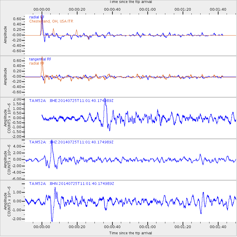
Signal To Noise
| Channel | StoN | STA | LTA |
| TA:M52A: :BHZ:20140725T11:01:40.174989Z | 6.1859384 | 1.0900859E-6 | 1.7621997E-7 |
| TA:M52A: :BHN:20140725T11:01:40.174989Z | 2.3851717 | 4.0412962E-7 | 1.694342E-7 |
| TA:M52A: :BHE:20140725T11:01:40.174989Z | 2.8435962 | 4.256026E-7 | 1.4967054E-7 |
| Arrivals |
| Ps | 2.4 SECOND |
| PpPs | 8.4 SECOND |
| PsPs/PpSs | 11 SECOND |


