You are here: Home > Network List > TA - USArray Transportable Network (new EarthScope stations) Stations List
> Station M60A Port Jervis, NY, USA > Earthquake Result Viewer
M60A Port Jervis, NY, USA - Earthquake Result Viewer
| Earthquake location: |
Southeastern Alaska |
| Earthquake latitude/longitude: |
58.4/-137.1 |
| Earthquake time(UTC): |
2014/07/25 (206) 10:54:49 GMT |
| Earthquake Depth: |
10 km |
| Earthquake Magnitude: |
5.9 MWP |
| Earthquake Catalog/Contributor: |
NEIC PDE/NEIC COMCAT |
|
| Network: |
TA USArray Transportable Network (new EarthScope stations) |
| Station: |
M60A Port Jervis, NY, USA |
| Lat/Lon: |
41.33 N/74.62 W |
| Elevation: |
292 m |
|
| Distance: |
42.1 deg |
| Az: |
85.607 deg |
| Baz: |
315.742 deg |
| Ray Param: |
0.07338869 |
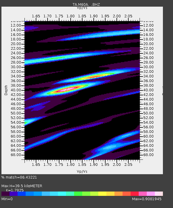
| Estimated Moho Depth: |
39.5 km |
| Estimated Crust Vp/Vs: |
1.78 |
| Assumed Crust Vp: |
6.283 km/s |
| Estimated Crust Vs: |
3.525 km/s |
| Estimated Crust Poisson's Ratio: |
0.27 |
|
| Radial Match: |
86.43221 % |
| Radial Bump: |
381 |
| Transverse Match: |
51.029808 % |
| Transverse Bump: |
400 |
| SOD ConfigId: |
769524 |
| Insert Time: |
2014-08-08 11:54:05.028 +0000 |
| GWidth: |
2.5 |
| Max Bumps: |
400 |
| Tol: |
0.001 |
|

Signal To Noise
| Channel | StoN | STA | LTA |
| TA:M60A: :BHZ:20140725T11:02:10.774995Z | 5.975802 | 7.380336E-7 | 1.2350368E-7 |
| TA:M60A: :BHN:20140725T11:02:10.774995Z | 4.3247333 | 4.187516E-7 | 9.682715E-8 |
| TA:M60A: :BHE:20140725T11:02:10.774995Z | 2.6873367 | 3.9669038E-7 | 1.476147E-7 |
| Arrivals |
| Ps | 5.2 SECOND |
| PpPs | 16 SECOND |
| PsPs/PpSs | 22 SECOND |


