You are here: Home > Network List > TA - USArray Transportable Network (new EarthScope stations) Stations List
> Station M63A Gales Ferry, CT, USA > Earthquake Result Viewer
M63A Gales Ferry, CT, USA - Earthquake Result Viewer
| Earthquake location: |
Southeastern Alaska |
| Earthquake latitude/longitude: |
58.4/-137.1 |
| Earthquake time(UTC): |
2014/07/25 (206) 10:54:49 GMT |
| Earthquake Depth: |
10 km |
| Earthquake Magnitude: |
5.9 MWP |
| Earthquake Catalog/Contributor: |
NEIC PDE/NEIC COMCAT |
|
| Network: |
TA USArray Transportable Network (new EarthScope stations) |
| Station: |
M63A Gales Ferry, CT, USA |
| Lat/Lon: |
41.40 N/72.05 W |
| Elevation: |
44 m |
|
| Distance: |
43.4 deg |
| Az: |
83.476 deg |
| Baz: |
315.874 deg |
| Ray Param: |
0.07259686 |
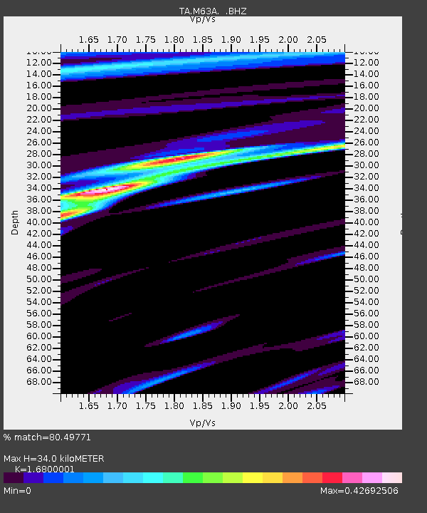
| Estimated Moho Depth: |
34.0 km |
| Estimated Crust Vp/Vs: |
1.68 |
| Assumed Crust Vp: |
6.472 km/s |
| Estimated Crust Vs: |
3.852 km/s |
| Estimated Crust Poisson's Ratio: |
0.23 |
|
| Radial Match: |
80.49771 % |
| Radial Bump: |
396 |
| Transverse Match: |
57.997356 % |
| Transverse Bump: |
400 |
| SOD ConfigId: |
769524 |
| Insert Time: |
2014-08-08 11:54:17.915 +0000 |
| GWidth: |
2.5 |
| Max Bumps: |
400 |
| Tol: |
0.001 |
|

Signal To Noise
| Channel | StoN | STA | LTA |
| TA:M63A: :BHZ:20140725T11:02:21.299989Z | 3.5598853 | 9.0566624E-7 | 2.5440883E-7 |
| TA:M63A: :BHN:20140725T11:02:21.299989Z | 1.9333658 | 4.363494E-7 | 2.2569418E-7 |
| TA:M63A: :BHE:20140725T11:02:21.299989Z | 2.7595675 | 3.6090864E-7 | 1.307845E-7 |
| Arrivals |
| Ps | 3.8 SECOND |
| PpPs | 13 SECOND |
| PsPs/PpSs | 17 SECOND |


