You are here: Home > Network List > TA - USArray Transportable Network (new EarthScope stations) Stations List
> Station O52A Adamsville, OH, USA > Earthquake Result Viewer
O52A Adamsville, OH, USA - Earthquake Result Viewer
| Earthquake location: |
Southeastern Alaska |
| Earthquake latitude/longitude: |
58.4/-137.1 |
| Earthquake time(UTC): |
2014/07/25 (206) 10:54:49 GMT |
| Earthquake Depth: |
10 km |
| Earthquake Magnitude: |
5.9 MWP |
| Earthquake Catalog/Contributor: |
NEIC PDE/NEIC COMCAT |
|
| Network: |
TA USArray Transportable Network (new EarthScope stations) |
| Station: |
O52A Adamsville, OH, USA |
| Lat/Lon: |
40.12 N/81.84 W |
| Elevation: |
331 m |
|
| Distance: |
39.1 deg |
| Az: |
92.969 deg |
| Baz: |
316.646 deg |
| Ray Param: |
0.07515372 |
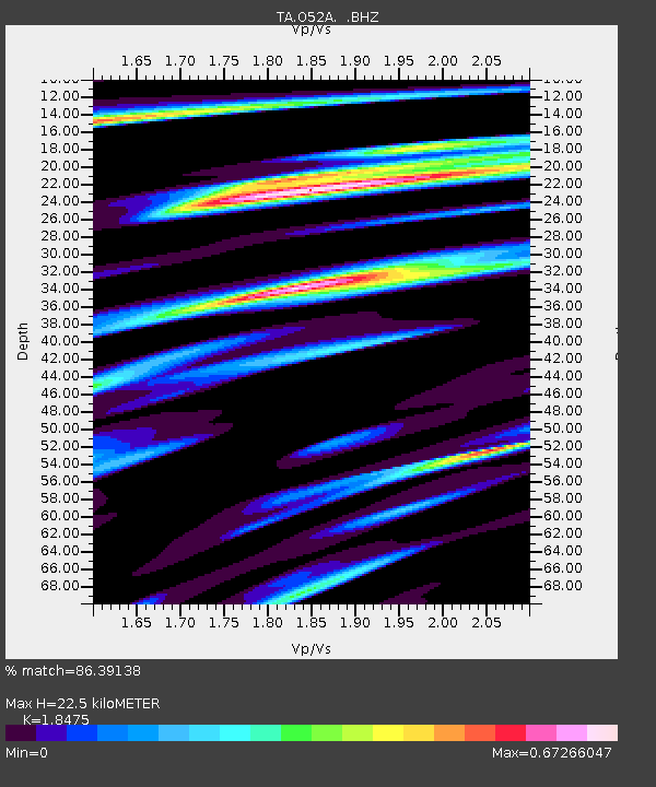
| Estimated Moho Depth: |
22.5 km |
| Estimated Crust Vp/Vs: |
1.85 |
| Assumed Crust Vp: |
6.483 km/s |
| Estimated Crust Vs: |
3.509 km/s |
| Estimated Crust Poisson's Ratio: |
0.29 |
|
| Radial Match: |
86.39138 % |
| Radial Bump: |
376 |
| Transverse Match: |
70.20177 % |
| Transverse Bump: |
400 |
| SOD ConfigId: |
769524 |
| Insert Time: |
2014-08-08 11:55:58.723 +0000 |
| GWidth: |
2.5 |
| Max Bumps: |
400 |
| Tol: |
0.001 |
|

Signal To Noise
| Channel | StoN | STA | LTA |
| TA:O52A: :BHZ:20140725T11:01:46.625001Z | 7.207595 | 1.3838963E-6 | 1.9200529E-7 |
| TA:O52A: :BHN:20140725T11:01:46.625001Z | 4.3836656 | 6.485395E-7 | 1.4794458E-7 |
| TA:O52A: :BHE:20140725T11:01:46.625001Z | 3.1653874 | 5.307184E-7 | 1.6766302E-7 |
| Arrivals |
| Ps | 3.2 SECOND |
| PpPs | 9.2 SECOND |
| PsPs/PpSs | 12 SECOND |


