You are here: Home > Network List > AK - Alaska Regional Network Stations List
> Station MESA Mesa, AK, USA > Earthquake Result Viewer
MESA Mesa, AK, USA - Earthquake Result Viewer
| Earthquake location: |
Tonga Islands |
| Earthquake latitude/longitude: |
-15.2/-173.2 |
| Earthquake time(UTC): |
2015/04/07 (097) 00:46:18 GMT |
| Earthquake Depth: |
10 km |
| Earthquake Magnitude: |
5.8 MB |
| Earthquake Catalog/Contributor: |
NEIC PDE/NEIC ALERT |
|
| Network: |
AK Alaska Regional Network |
| Station: |
MESA Mesa, AK, USA |
| Lat/Lon: |
60.18 N/141.95 W |
| Elevation: |
1919 m |
|
| Distance: |
79.2 deg |
| Az: |
15.314 deg |
| Baz: |
210.674 deg |
| Ray Param: |
0.049100928 |
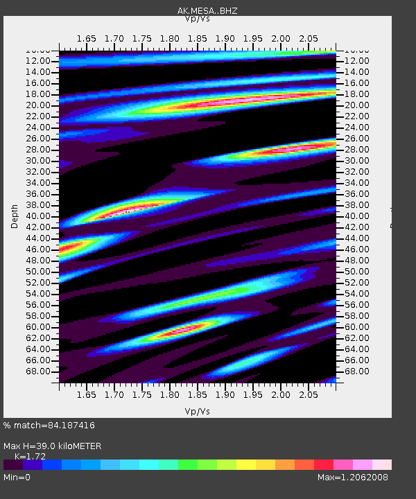
| Estimated Moho Depth: |
39.0 km |
| Estimated Crust Vp/Vs: |
1.72 |
| Assumed Crust Vp: |
6.566 km/s |
| Estimated Crust Vs: |
3.818 km/s |
| Estimated Crust Poisson's Ratio: |
0.24 |
|
| Radial Match: |
84.187416 % |
| Radial Bump: |
376 |
| Transverse Match: |
75.44305 % |
| Transverse Bump: |
400 |
| SOD ConfigId: |
7422571 |
| Insert Time: |
2019-04-18 02:54:50.185 +0000 |
| GWidth: |
2.5 |
| Max Bumps: |
400 |
| Tol: |
0.001 |
|

Signal To Noise
| Channel | StoN | STA | LTA |
| AK:MESA: :BHZ:20150407T00:57:53.008008Z | 11.939602 | 3.539992E-6 | 2.964916E-7 |
| AK:MESA: :BHN:20150407T00:57:53.008008Z | 1.9037153 | 8.2220384E-7 | 4.318943E-7 |
| AK:MESA: :BHE:20150407T00:57:53.008008Z | 2.1631541 | 8.270422E-7 | 3.823316E-7 |
| Arrivals |
| Ps | 4.4 SECOND |
| PpPs | 16 SECOND |
| PsPs/PpSs | 20 SECOND |


