You are here: Home > Network List > TA - USArray Transportable Network (new EarthScope stations) Stations List
> Station P53A Whipple, OH, USA > Earthquake Result Viewer
P53A Whipple, OH, USA - Earthquake Result Viewer
| Earthquake location: |
Southeastern Alaska |
| Earthquake latitude/longitude: |
58.4/-137.1 |
| Earthquake time(UTC): |
2014/07/25 (206) 10:54:49 GMT |
| Earthquake Depth: |
10 km |
| Earthquake Magnitude: |
5.9 MWP |
| Earthquake Catalog/Contributor: |
NEIC PDE/NEIC COMCAT |
|
| Network: |
TA USArray Transportable Network (new EarthScope stations) |
| Station: |
P53A Whipple, OH, USA |
| Lat/Lon: |
39.49 N/81.39 W |
| Elevation: |
270 m |
|
| Distance: |
39.8 deg |
| Az: |
93.249 deg |
| Baz: |
317.147 deg |
| Ray Param: |
0.07474985 |
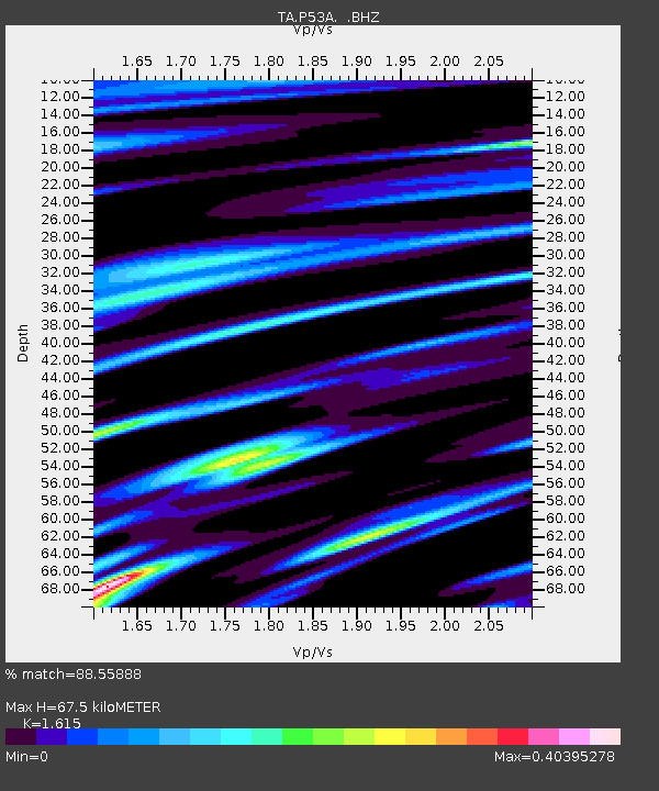
| Estimated Moho Depth: |
67.5 km |
| Estimated Crust Vp/Vs: |
1.62 |
| Assumed Crust Vp: |
6.207 km/s |
| Estimated Crust Vs: |
3.843 km/s |
| Estimated Crust Poisson's Ratio: |
0.19 |
|
| Radial Match: |
88.55888 % |
| Radial Bump: |
271 |
| Transverse Match: |
61.27413 % |
| Transverse Bump: |
400 |
| SOD ConfigId: |
769524 |
| Insert Time: |
2014-08-08 11:56:53.893 +0000 |
| GWidth: |
2.5 |
| Max Bumps: |
400 |
| Tol: |
0.001 |
|

Signal To Noise
| Channel | StoN | STA | LTA |
| TA:P53A: :BHZ:20140725T11:01:52.399995Z | 7.229213 | 1.317993E-6 | 1.8231485E-7 |
| TA:P53A: :BHN:20140725T11:01:52.399995Z | 3.1497366 | 4.5656404E-7 | 1.4495309E-7 |
| TA:P53A: :BHE:20140725T11:01:52.399995Z | 2.819517 | 4.5130074E-7 | 1.6006315E-7 |
| Arrivals |
| Ps | 7.2 SECOND |
| PpPs | 26 SECOND |
| PsPs/PpSs | 34 SECOND |


