You are here: Home > Network List > TA - USArray Transportable Network (new EarthScope stations) Stations List
> Station P57A Homestead Farm, Martinsburg, WV, USA > Earthquake Result Viewer
P57A Homestead Farm, Martinsburg, WV, USA - Earthquake Result Viewer
| Earthquake location: |
Southeastern Alaska |
| Earthquake latitude/longitude: |
58.4/-137.1 |
| Earthquake time(UTC): |
2014/07/25 (206) 10:54:49 GMT |
| Earthquake Depth: |
10 km |
| Earthquake Magnitude: |
5.9 MWP |
| Earthquake Catalog/Contributor: |
NEIC PDE/NEIC COMCAT |
|
| Network: |
TA USArray Transportable Network (new EarthScope stations) |
| Station: |
P57A Homestead Farm, Martinsburg, WV, USA |
| Lat/Lon: |
39.48 N/78.01 W |
| Elevation: |
191 m |
|
| Distance: |
41.6 deg |
| Az: |
90.318 deg |
| Baz: |
317.065 deg |
| Ray Param: |
0.07367758 |
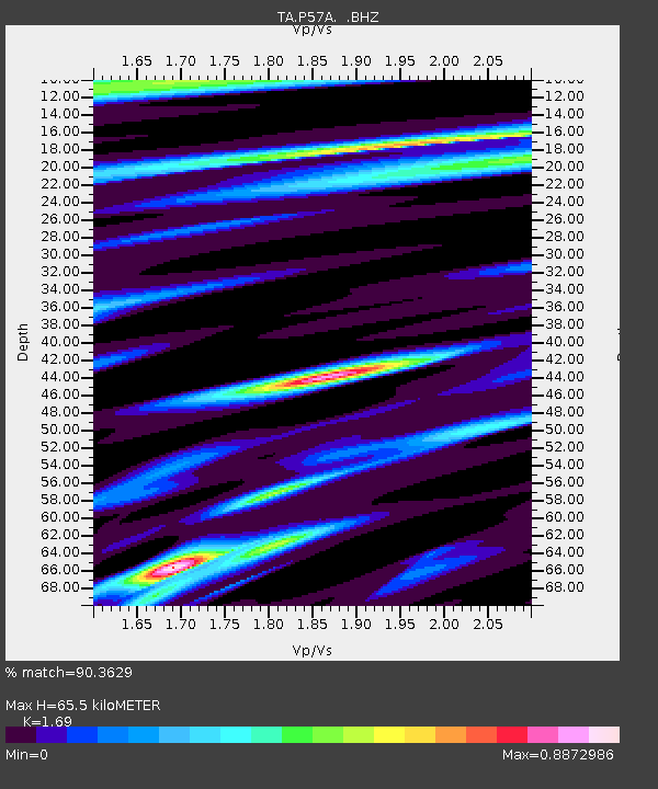
| Estimated Moho Depth: |
65.5 km |
| Estimated Crust Vp/Vs: |
1.69 |
| Assumed Crust Vp: |
6.159 km/s |
| Estimated Crust Vs: |
3.644 km/s |
| Estimated Crust Poisson's Ratio: |
0.23 |
|
| Radial Match: |
90.3629 % |
| Radial Bump: |
325 |
| Transverse Match: |
61.506927 % |
| Transverse Bump: |
400 |
| SOD ConfigId: |
769524 |
| Insert Time: |
2014-08-08 11:57:14.685 +0000 |
| GWidth: |
2.5 |
| Max Bumps: |
400 |
| Tol: |
0.001 |
|
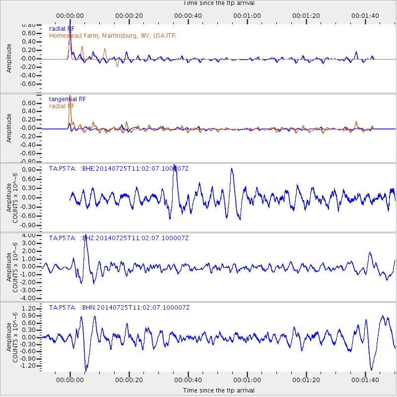
Signal To Noise
| Channel | StoN | STA | LTA |
| TA:P57A: :BHZ:20140725T11:02:07.100007Z | 4.7697754 | 9.900219E-7 | 2.0756153E-7 |
| TA:P57A: :BHN:20140725T11:02:07.100007Z | 3.7671752 | 3.766119E-7 | 9.997196E-8 |
| TA:P57A: :BHE:20140725T11:02:07.100007Z | 1.6836276 | 2.668465E-7 | 1.5849497E-7 |
| Arrivals |
| Ps | 7.8 SECOND |
| PpPs | 27 SECOND |
| PsPs/PpSs | 35 SECOND |


