You are here: Home > Network List > TA - USArray Transportable Network (new EarthScope stations) Stations List
> Station Q53A Leroy, WV, USA > Earthquake Result Viewer
Q53A Leroy, WV, USA - Earthquake Result Viewer
| Earthquake location: |
Southeastern Alaska |
| Earthquake latitude/longitude: |
58.4/-137.1 |
| Earthquake time(UTC): |
2014/07/25 (206) 10:54:49 GMT |
| Earthquake Depth: |
10 km |
| Earthquake Magnitude: |
5.9 MWP |
| Earthquake Catalog/Contributor: |
NEIC PDE/NEIC COMCAT |
|
| Network: |
TA USArray Transportable Network (new EarthScope stations) |
| Station: |
Q53A Leroy, WV, USA |
| Lat/Lon: |
38.86 N/81.53 W |
| Elevation: |
310 m |
|
| Distance: |
40.2 deg |
| Az: |
94.03 deg |
| Baz: |
317.66 deg |
| Ray Param: |
0.07451469 |
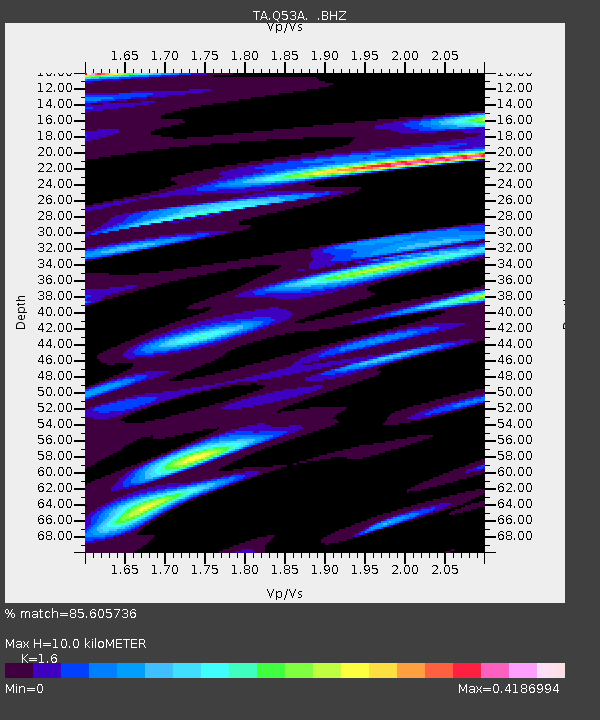
| Estimated Moho Depth: |
10.0 km |
| Estimated Crust Vp/Vs: |
1.60 |
| Assumed Crust Vp: |
6.207 km/s |
| Estimated Crust Vs: |
3.879 km/s |
| Estimated Crust Poisson's Ratio: |
0.18 |
|
| Radial Match: |
85.605736 % |
| Radial Bump: |
293 |
| Transverse Match: |
54.239662 % |
| Transverse Bump: |
386 |
| SOD ConfigId: |
769524 |
| Insert Time: |
2014-08-08 11:57:43.068 +0000 |
| GWidth: |
2.5 |
| Max Bumps: |
400 |
| Tol: |
0.001 |
|

Signal To Noise
| Channel | StoN | STA | LTA |
| TA:Q53A: :BHZ:20140725T11:01:55.649995Z | 8.434875 | 1.491414E-6 | 1.768152E-7 |
| TA:Q53A: :BHN:20140725T11:01:55.649995Z | 2.5134377 | 4.0141987E-7 | 1.5970949E-7 |
| TA:Q53A: :BHE:20140725T11:01:55.649995Z | 2.4118657 | 5.188897E-7 | 2.1514037E-7 |
| Arrivals |
| Ps | 1.0 SECOND |
| PpPs | 3.9 SECOND |
| PsPs/PpSs | 4.9 SECOND |


