You are here: Home > Network List > AK - Alaska Regional Network Stations List
> Station TRF Thorofare Mountian > Earthquake Result Viewer
TRF Thorofare Mountian - Earthquake Result Viewer
| Earthquake location: |
Tonga Islands |
| Earthquake latitude/longitude: |
-15.2/-173.2 |
| Earthquake time(UTC): |
2015/04/07 (097) 00:46:18 GMT |
| Earthquake Depth: |
10 km |
| Earthquake Magnitude: |
5.8 MB |
| Earthquake Catalog/Contributor: |
NEIC PDE/NEIC ALERT |
|
| Network: |
AK Alaska Regional Network |
| Station: |
TRF Thorofare Mountian |
| Lat/Lon: |
63.45 N/150.29 W |
| Elevation: |
1717 m |
|
| Distance: |
80.4 deg |
| Az: |
10.23 deg |
| Baz: |
202.432 deg |
| Ray Param: |
0.048304442 |
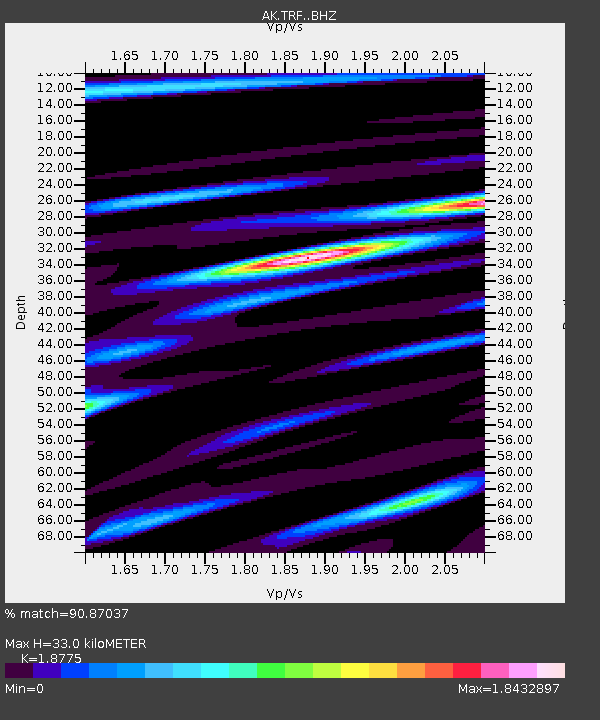
| Estimated Moho Depth: |
33.0 km |
| Estimated Crust Vp/Vs: |
1.88 |
| Assumed Crust Vp: |
6.438 km/s |
| Estimated Crust Vs: |
3.429 km/s |
| Estimated Crust Poisson's Ratio: |
0.30 |
|
| Radial Match: |
90.87037 % |
| Radial Bump: |
339 |
| Transverse Match: |
86.47111 % |
| Transverse Bump: |
400 |
| SOD ConfigId: |
7422571 |
| Insert Time: |
2019-04-18 02:55:15.488 +0000 |
| GWidth: |
2.5 |
| Max Bumps: |
400 |
| Tol: |
0.001 |
|

Signal To Noise
| Channel | StoN | STA | LTA |
| AK:TRF: :BHZ:20150407T00:57:59.227979Z | 37.754856 | 4.06018E-6 | 1.075406E-7 |
| AK:TRF: :BHN:20150407T00:57:59.227979Z | 7.3992467 | 1.6597745E-6 | 2.2431668E-7 |
| AK:TRF: :BHE:20150407T00:57:59.227979Z | 2.4770744 | 7.177654E-7 | 2.8976334E-7 |
| Arrivals |
| Ps | 4.6 SECOND |
| PpPs | 14 SECOND |
| PsPs/PpSs | 19 SECOND |


