You are here: Home > Network List > TA - USArray Transportable Network (new EarthScope stations) Stations List
> Station R56A Bull Pasture Mountain, McDowell, VA, USA > Earthquake Result Viewer
R56A Bull Pasture Mountain, McDowell, VA, USA - Earthquake Result Viewer
| Earthquake location: |
Southeastern Alaska |
| Earthquake latitude/longitude: |
58.4/-137.1 |
| Earthquake time(UTC): |
2014/07/25 (206) 10:54:49 GMT |
| Earthquake Depth: |
10 km |
| Earthquake Magnitude: |
5.9 MWP |
| Earthquake Catalog/Contributor: |
NEIC PDE/NEIC COMCAT |
|
| Network: |
TA USArray Transportable Network (new EarthScope stations) |
| Station: |
R56A Bull Pasture Mountain, McDowell, VA, USA |
| Lat/Lon: |
38.41 N/79.40 W |
| Elevation: |
902 m |
|
| Distance: |
41.7 deg |
| Az: |
92.614 deg |
| Baz: |
317.91 deg |
| Ray Param: |
0.073639795 |
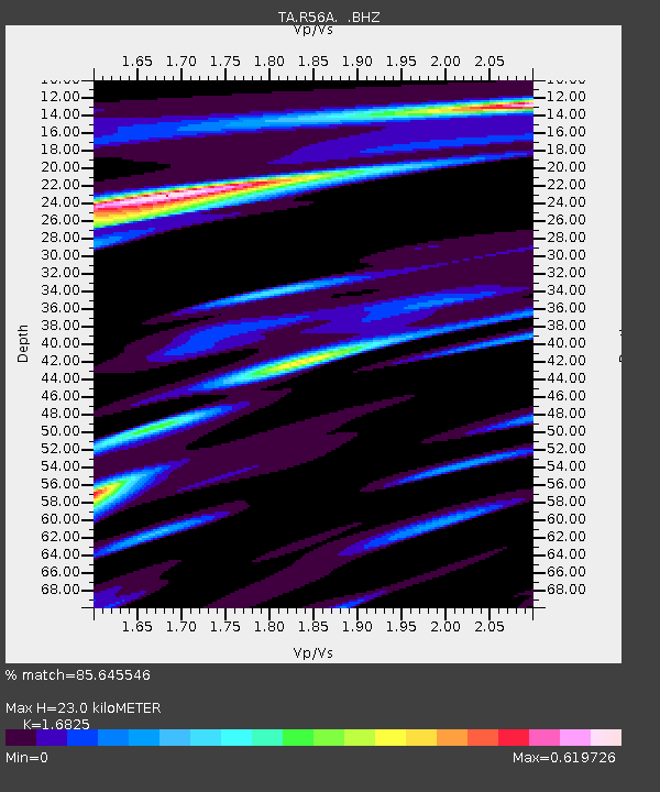
| Estimated Moho Depth: |
23.0 km |
| Estimated Crust Vp/Vs: |
1.68 |
| Assumed Crust Vp: |
6.159 km/s |
| Estimated Crust Vs: |
3.66 km/s |
| Estimated Crust Poisson's Ratio: |
0.23 |
|
| Radial Match: |
85.645546 % |
| Radial Bump: |
293 |
| Transverse Match: |
63.6645 % |
| Transverse Bump: |
380 |
| SOD ConfigId: |
769524 |
| Insert Time: |
2014-08-08 11:58:36.521 +0000 |
| GWidth: |
2.5 |
| Max Bumps: |
400 |
| Tol: |
0.001 |
|
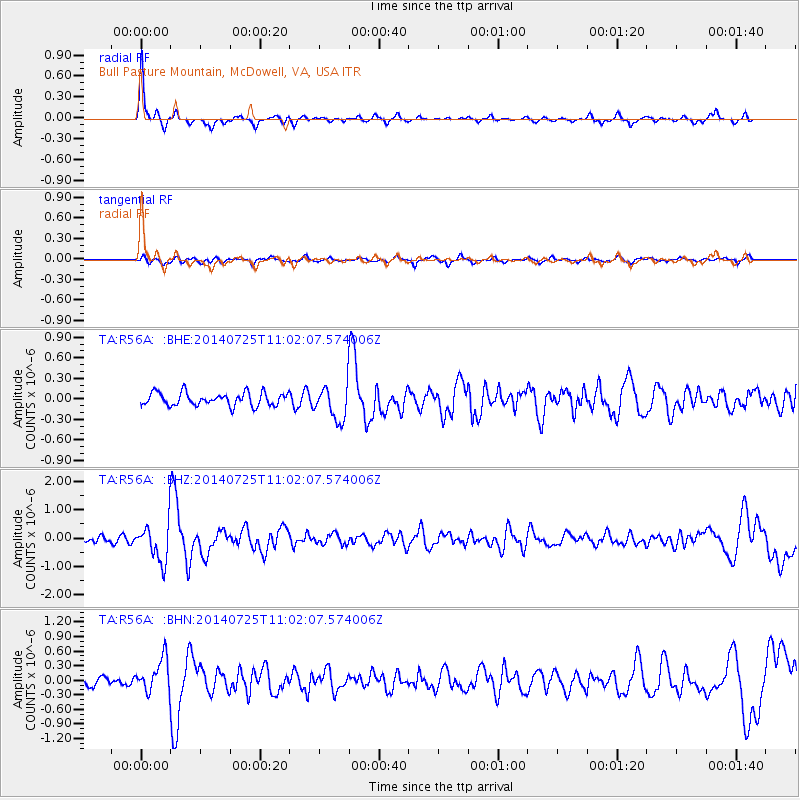
Signal To Noise
| Channel | StoN | STA | LTA |
| TA:R56A: :BHZ:20140725T11:02:07.574006Z | 6.4290686 | 6.6751494E-7 | 1.03827624E-7 |
| TA:R56A: :BHN:20140725T11:02:07.574006Z | 2.7143328 | 3.400428E-7 | 1.2527676E-7 |
| TA:R56A: :BHE:20140725T11:02:07.574006Z | 2.6345258 | 2.4949057E-7 | 9.470037E-8 |
| Arrivals |
| Ps | 2.7 SECOND |
| PpPs | 9.4 SECOND |
| PsPs/PpSs | 12 SECOND |


