You are here: Home > Network List > TA - USArray Transportable Network (new EarthScope stations) Stations List
> Station R58B Mineral, VA, USA > Earthquake Result Viewer
R58B Mineral, VA, USA - Earthquake Result Viewer
| Earthquake location: |
Southeastern Alaska |
| Earthquake latitude/longitude: |
58.4/-137.1 |
| Earthquake time(UTC): |
2014/07/25 (206) 10:54:49 GMT |
| Earthquake Depth: |
10 km |
| Earthquake Magnitude: |
5.9 MWP |
| Earthquake Catalog/Contributor: |
NEIC PDE/NEIC COMCAT |
|
| Network: |
TA USArray Transportable Network (new EarthScope stations) |
| Station: |
R58B Mineral, VA, USA |
| Lat/Lon: |
37.96 N/77.88 W |
| Elevation: |
116 m |
|
| Distance: |
42.8 deg |
| Az: |
91.725 deg |
| Baz: |
318.19 deg |
| Ray Param: |
0.07295034 |
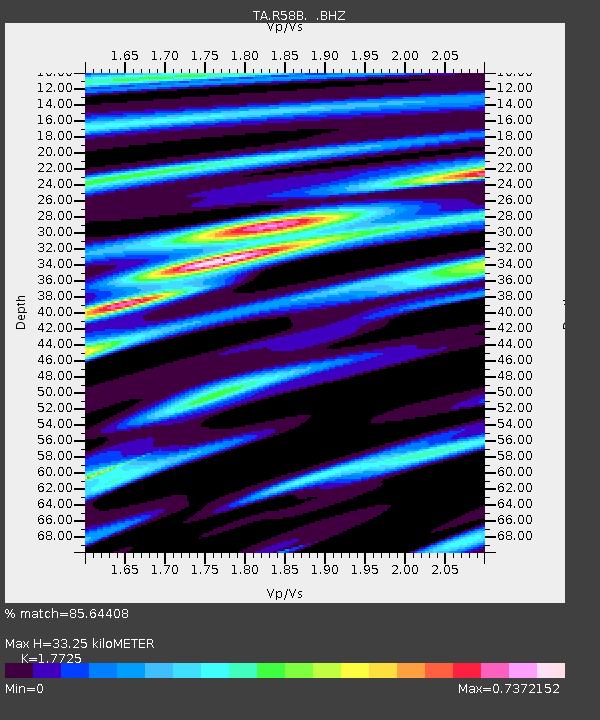
| Estimated Moho Depth: |
33.25 km |
| Estimated Crust Vp/Vs: |
1.77 |
| Assumed Crust Vp: |
6.565 km/s |
| Estimated Crust Vs: |
3.704 km/s |
| Estimated Crust Poisson's Ratio: |
0.27 |
|
| Radial Match: |
85.64408 % |
| Radial Bump: |
309 |
| Transverse Match: |
66.54661 % |
| Transverse Bump: |
400 |
| SOD ConfigId: |
769524 |
| Insert Time: |
2014-08-08 11:58:57.132 +0000 |
| GWidth: |
2.5 |
| Max Bumps: |
400 |
| Tol: |
0.001 |
|
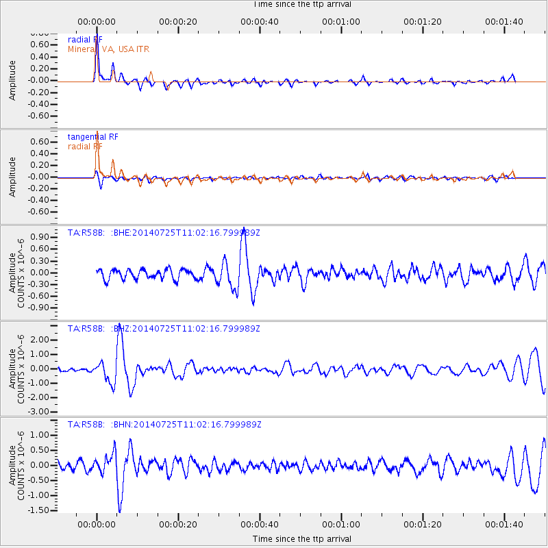
Signal To Noise
| Channel | StoN | STA | LTA |
| TA:R58B: :BHZ:20140725T11:02:16.799989Z | 5.30004 | 7.2607594E-7 | 1.3699444E-7 |
| TA:R58B: :BHN:20140725T11:02:16.799989Z | 2.7381835 | 3.1599154E-7 | 1.1540189E-7 |
| TA:R58B: :BHE:20140725T11:02:16.799989Z | 2.737007 | 3.3262384E-7 | 1.2152832E-7 |
| Arrivals |
| Ps | 4.2 SECOND |
| PpPs | 13 SECOND |
| PsPs/PpSs | 17 SECOND |


