You are here: Home > Network List > TA - USArray Transportable Network (new EarthScope stations) Stations List
> Station T53A Wise, VA, USA > Earthquake Result Viewer
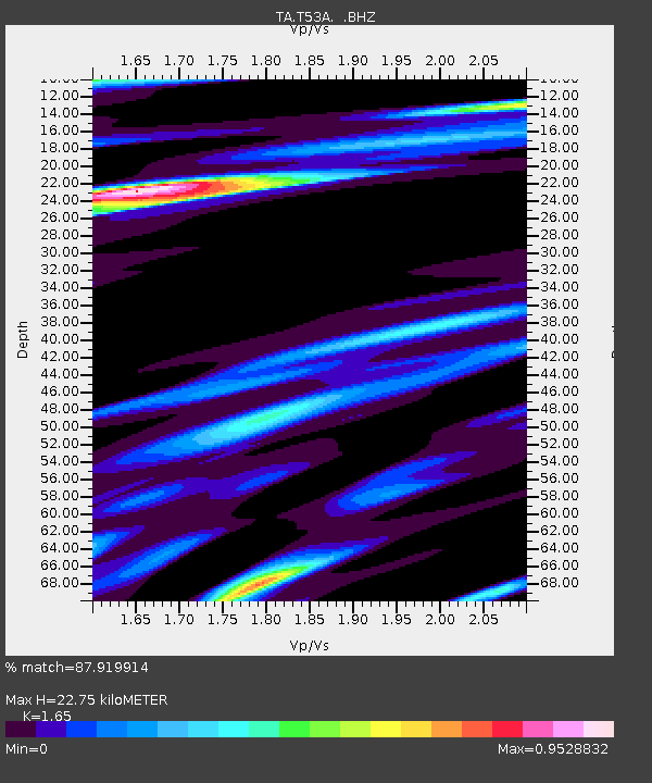
T53A Wise, VA, USA - Earthquake Result Viewer
| Earthquake location: |
Southeastern Alaska |
| Earthquake latitude/longitude: |
58.4/-137.1 |
| Earthquake time(UTC): |
2014/07/25 (206) 10:54:49 GMT |
| Earthquake Depth: |
10 km |
| Earthquake Magnitude: |
5.9 MWP |
| Earthquake Catalog/Contributor: |
NEIC PDE/NEIC COMCAT |
|
| Network: |
TA USArray Transportable Network (new EarthScope stations) |
| Station: |
T53A Wise, VA, USA |
| Lat/Lon: |
36.98 N/82.54 W |
| Elevation: |
818 m |
|
| Distance: |
41.1 deg |
| Az: |
96.854 deg |
| Baz: |
319.184 deg |
| Ray Param: |
0.074003525 |
| Estimated Moho Depth: |
22.75 km |
| Estimated Crust Vp/Vs: |
1.65 |
| Assumed Crust Vp: |
6.476 km/s |
| Estimated Crust Vs: |
3.925 km/s |
| Estimated Crust Poisson's Ratio: |
0.21 |
|
| Radial Match: |
87.919914 % |
| Radial Bump: |
400 |
| Transverse Match: |
64.126564 % |
| Transverse Bump: |
400 |
| SOD ConfigId: |
769524 |
| Insert Time: |
2014-08-08 11:59:53.753 +0000 |
| GWidth: |
2.5 |
| Max Bumps: |
400 |
| Tol: |
0.001 |
|

Signal To Noise
| Channel | StoN | STA | LTA |
| TA:T53A: :BHZ:20140725T11:02:02.825013Z | 5.48488 | 1.0651773E-6 | 1.942025E-7 |
| TA:T53A: :BHN:20140725T11:02:02.825013Z | 2.238485 | 3.9868735E-7 | 1.7810588E-7 |
| TA:T53A: :BHE:20140725T11:02:02.825013Z | 2.2430937 | 3.6157138E-7 | 1.6119317E-7 |
| Arrivals |
| Ps | 2.5 SECOND |
| PpPs | 8.6 SECOND |
| PsPs/PpSs | 11 SECOND |


