You are here: Home > Network List > TA - USArray Transportable Network (new EarthScope stations) Stations List
> Station T60A Surry, VA, USA > Earthquake Result Viewer
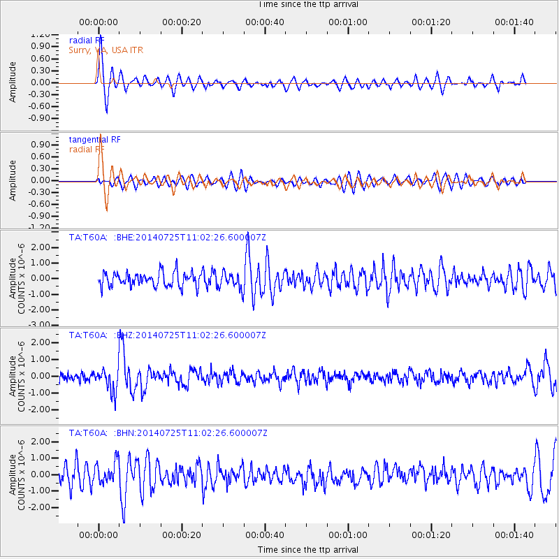
T60A Surry, VA, USA - Earthquake Result Viewer
*The percent match for this event was below the threshold and hence no stack was calculated.
| Earthquake location: |
Southeastern Alaska |
| Earthquake latitude/longitude: |
58.4/-137.1 |
| Earthquake time(UTC): |
2014/07/25 (206) 10:54:49 GMT |
| Earthquake Depth: |
10 km |
| Earthquake Magnitude: |
5.9 MWP |
| Earthquake Catalog/Contributor: |
NEIC PDE/NEIC COMCAT |
|
| Network: |
TA USArray Transportable Network (new EarthScope stations) |
| Station: |
T60A Surry, VA, USA |
| Lat/Lon: |
37.14 N/76.73 W |
| Elevation: |
11 m |
|
| Distance: |
44.0 deg |
| Az: |
91.529 deg |
| Baz: |
318.742 deg |
| Ray Param: |
$rayparam |
*The percent match for this event was below the threshold and hence was not used in the summary stack. |
|
| Radial Match: |
73.06875 % |
| Radial Bump: |
400 |
| Transverse Match: |
54.350426 % |
| Transverse Bump: |
400 |
| SOD ConfigId: |
769524 |
| Insert Time: |
2014-08-08 12:00:21.326 +0000 |
| GWidth: |
2.5 |
| Max Bumps: |
400 |
| Tol: |
0.001 |
|
Signal To Noise
| Channel | StoN | STA | LTA |
| TA:T60A: :BHZ:20140725T11:02:26.600007Z | 3.219779 | 6.9492813E-7 | 2.15831E-7 |
| TA:T60A: :BHN:20140725T11:02:26.600007Z | 1.3448653 | 6.9140526E-7 | 5.141074E-7 |
| TA:T60A: :BHE:20140725T11:02:26.600007Z | 1.172833 | 5.237494E-7 | 4.465678E-7 |
| Arrivals |
| Ps | |
| PpPs | |
| PsPs/PpSs | |


