You are here: Home > Network List > TA - USArray Transportable Network (new EarthScope stations) Stations List
> Station U55A TA2, Sparta, NC, USA > Earthquake Result Viewer
U55A TA2, Sparta, NC, USA - Earthquake Result Viewer
| Earthquake location: |
Southeastern Alaska |
| Earthquake latitude/longitude: |
58.4/-137.1 |
| Earthquake time(UTC): |
2014/07/25 (206) 10:54:49 GMT |
| Earthquake Depth: |
10 km |
| Earthquake Magnitude: |
5.9 MWP |
| Earthquake Catalog/Contributor: |
NEIC PDE/NEIC COMCAT |
|
| Network: |
TA USArray Transportable Network (new EarthScope stations) |
| Station: |
U55A TA2, Sparta, NC, USA |
| Lat/Lon: |
36.50 N/81.05 W |
| Elevation: |
863 m |
|
| Distance: |
42.2 deg |
| Az: |
95.962 deg |
| Baz: |
319.404 deg |
| Ray Param: |
0.07328691 |
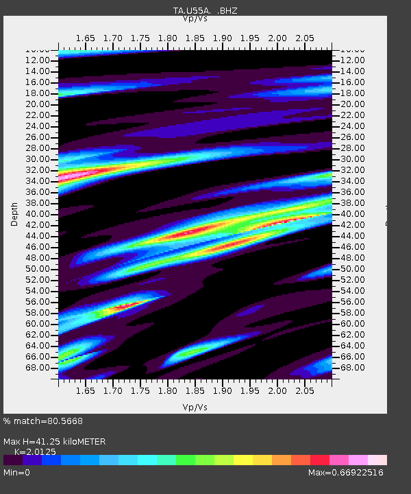
| Estimated Moho Depth: |
41.25 km |
| Estimated Crust Vp/Vs: |
2.01 |
| Assumed Crust Vp: |
6.159 km/s |
| Estimated Crust Vs: |
3.06 km/s |
| Estimated Crust Poisson's Ratio: |
0.34 |
|
| Radial Match: |
80.5668 % |
| Radial Bump: |
195 |
| Transverse Match: |
60.647175 % |
| Transverse Bump: |
400 |
| SOD ConfigId: |
769524 |
| Insert Time: |
2014-08-08 12:00:45.679 +0000 |
| GWidth: |
2.5 |
| Max Bumps: |
400 |
| Tol: |
0.001 |
|
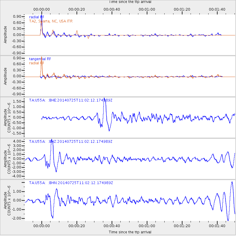
Signal To Noise
| Channel | StoN | STA | LTA |
| TA:U55A: :BHZ:20140725T11:02:12.174989Z | 5.1714554 | 9.537257E-7 | 1.8442114E-7 |
| TA:U55A: :BHN:20140725T11:02:12.174989Z | 4.339523 | 3.5814568E-7 | 8.2531116E-8 |
| TA:U55A: :BHE:20140725T11:02:12.174989Z | 4.8633766 | 4.2151134E-7 | 8.667051E-8 |
| Arrivals |
| Ps | 7.2 SECOND |
| PpPs | 19 SECOND |
| PsPs/PpSs | 26 SECOND |


