You are here: Home > Network List > TA - USArray Transportable Network (new EarthScope stations) Stations List
> Station U58A Oxford, NC, USA > Earthquake Result Viewer
U58A Oxford, NC, USA - Earthquake Result Viewer
| Earthquake location: |
Southeastern Alaska |
| Earthquake latitude/longitude: |
58.4/-137.1 |
| Earthquake time(UTC): |
2014/07/25 (206) 10:54:49 GMT |
| Earthquake Depth: |
10 km |
| Earthquake Magnitude: |
5.9 MWP |
| Earthquake Catalog/Contributor: |
NEIC PDE/NEIC COMCAT |
|
| Network: |
TA USArray Transportable Network (new EarthScope stations) |
| Station: |
U58A Oxford, NC, USA |
| Lat/Lon: |
36.39 N/78.55 W |
| Elevation: |
169 m |
|
| Distance: |
43.6 deg |
| Az: |
93.821 deg |
| Baz: |
319.314 deg |
| Ray Param: |
0.07242396 |
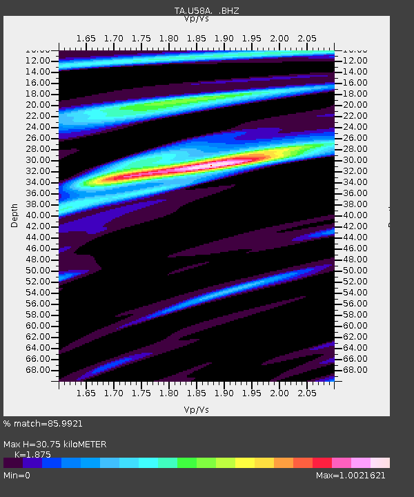
| Estimated Moho Depth: |
30.75 km |
| Estimated Crust Vp/Vs: |
1.88 |
| Assumed Crust Vp: |
6.419 km/s |
| Estimated Crust Vs: |
3.424 km/s |
| Estimated Crust Poisson's Ratio: |
0.30 |
|
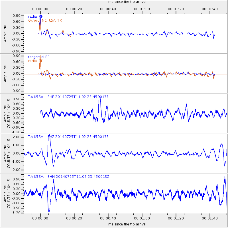
| Radial Match: |
85.9921 % |
| Radial Bump: |
348 |
| Transverse Match: |
57.8337 % |
| Transverse Bump: |
400 |
| SOD ConfigId: |
769524 |
| Insert Time: |
2014-08-08 12:00:58.827 +0000 |
| GWidth: |
2.5 |
| Max Bumps: |
400 |
| Tol: |
0.001 |
|
Signal To Noise
| Channel | StoN | STA | LTA |
| TA:U58A: :BHZ:20140725T11:02:23.450013Z | 6.2905993 | 7.3137863E-7 | 1.1626533E-7 |
| TA:U58A: :BHN:20140725T11:02:23.450013Z | 3.4191964 | 3.7372578E-7 | 1.0930223E-7 |
| TA:U58A: :BHE:20140725T11:02:23.450013Z | 3.1621795 | 3.5929057E-7 | 1.13621184E-7 |
| Arrivals |
| Ps | 4.5 SECOND |
| PpPs | 13 SECOND |
| PsPs/PpSs | 17 SECOND |


