You are here: Home > Network List > TA - USArray Transportable Network (new EarthScope stations) Stations List
> Station V54A Nebo, NC, USA > Earthquake Result Viewer
V54A Nebo, NC, USA - Earthquake Result Viewer
| Earthquake location: |
Southeastern Alaska |
| Earthquake latitude/longitude: |
58.4/-137.1 |
| Earthquake time(UTC): |
2014/07/25 (206) 10:54:49 GMT |
| Earthquake Depth: |
10 km |
| Earthquake Magnitude: |
5.9 MWP |
| Earthquake Catalog/Contributor: |
NEIC PDE/NEIC COMCAT |
|
| Network: |
TA USArray Transportable Network (new EarthScope stations) |
| Station: |
V54A Nebo, NC, USA |
| Lat/Lon: |
35.78 N/81.95 W |
| Elevation: |
448 m |
|
| Distance: |
42.3 deg |
| Az: |
97.484 deg |
| Baz: |
320.001 deg |
| Ray Param: |
0.07324066 |
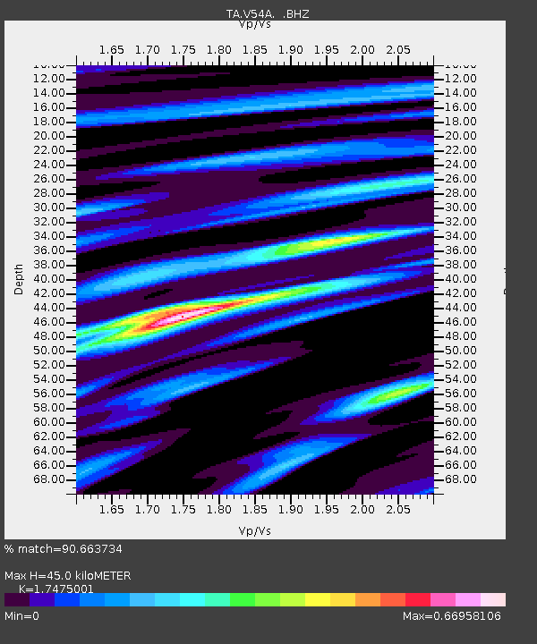
| Estimated Moho Depth: |
45.0 km |
| Estimated Crust Vp/Vs: |
1.75 |
| Assumed Crust Vp: |
6.419 km/s |
| Estimated Crust Vs: |
3.673 km/s |
| Estimated Crust Poisson's Ratio: |
0.26 |
|
| Radial Match: |
90.663734 % |
| Radial Bump: |
348 |
| Transverse Match: |
64.97285 % |
| Transverse Bump: |
400 |
| SOD ConfigId: |
769524 |
| Insert Time: |
2014-08-08 12:01:15.301 +0000 |
| GWidth: |
2.5 |
| Max Bumps: |
400 |
| Tol: |
0.001 |
|

Signal To Noise
| Channel | StoN | STA | LTA |
| TA:V54A: :BHZ:20140725T11:02:12.825013Z | 5.2444754 | 1.0634948E-6 | 2.0278381E-7 |
| TA:V54A: :BHN:20140725T11:02:12.825013Z | 3.5900052 | 5.051648E-7 | 1.4071422E-7 |
| TA:V54A: :BHE:20140725T11:02:12.825013Z | 4.3785977 | 5.2412577E-7 | 1.1970174E-7 |
| Arrivals |
| Ps | 5.6 SECOND |
| PpPs | 18 SECOND |
| PsPs/PpSs | 24 SECOND |


