You are here: Home > Network List > TA - USArray Transportable Network (new EarthScope stations) Stations List
> Station V58A Windy Hill, Pittsboro, NC, USA > Earthquake Result Viewer
V58A Windy Hill, Pittsboro, NC, USA - Earthquake Result Viewer
| Earthquake location: |
Southeastern Alaska |
| Earthquake latitude/longitude: |
58.4/-137.1 |
| Earthquake time(UTC): |
2014/07/25 (206) 10:54:49 GMT |
| Earthquake Depth: |
10 km |
| Earthquake Magnitude: |
5.9 MWP |
| Earthquake Catalog/Contributor: |
NEIC PDE/NEIC COMCAT |
|
| Network: |
TA USArray Transportable Network (new EarthScope stations) |
| Station: |
V58A Windy Hill, Pittsboro, NC, USA |
| Lat/Lon: |
35.79 N/79.11 W |
| Elevation: |
127 m |
|
| Distance: |
43.8 deg |
| Az: |
94.888 deg |
| Baz: |
319.754 deg |
| Ray Param: |
0.072320215 |
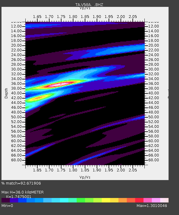
| Estimated Moho Depth: |
36.0 km |
| Estimated Crust Vp/Vs: |
1.75 |
| Assumed Crust Vp: |
6.565 km/s |
| Estimated Crust Vs: |
3.757 km/s |
| Estimated Crust Poisson's Ratio: |
0.26 |
|
| Radial Match: |
92.671906 % |
| Radial Bump: |
183 |
| Transverse Match: |
64.438644 % |
| Transverse Bump: |
400 |
| SOD ConfigId: |
769524 |
| Insert Time: |
2014-08-08 12:01:30.558 +0000 |
| GWidth: |
2.5 |
| Max Bumps: |
400 |
| Tol: |
0.001 |
|
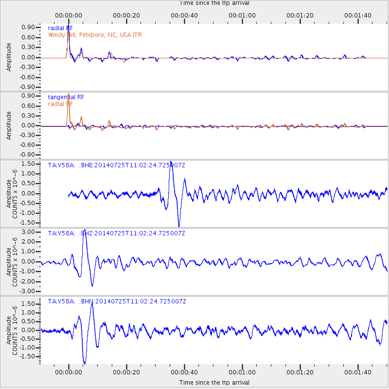
Signal To Noise
| Channel | StoN | STA | LTA |
| TA:V58A: :BHZ:20140725T11:02:24.725007Z | 6.1519365 | 7.812144E-7 | 1.2698675E-7 |
| TA:V58A: :BHN:20140725T11:02:24.725007Z | 4.785808 | 4.111445E-7 | 8.590911E-8 |
| TA:V58A: :BHE:20140725T11:02:24.725007Z | 3.6914895 | 3.656486E-7 | 9.905178E-8 |
| Arrivals |
| Ps | 4.4 SECOND |
| PpPs | 14 SECOND |
| PsPs/PpSs | 18 SECOND |


