You are here: Home > Network List > TA - USArray Transportable Network (new EarthScope stations) Stations List
> Station V59A Middlesex, NC, USA > Earthquake Result Viewer
V59A Middlesex, NC, USA - Earthquake Result Viewer
| Earthquake location: |
Southeastern Alaska |
| Earthquake latitude/longitude: |
58.4/-137.1 |
| Earthquake time(UTC): |
2014/07/25 (206) 10:54:49 GMT |
| Earthquake Depth: |
10 km |
| Earthquake Magnitude: |
5.9 MWP |
| Earthquake Catalog/Contributor: |
NEIC PDE/NEIC COMCAT |
|
| Network: |
TA USArray Transportable Network (new EarthScope stations) |
| Station: |
V59A Middlesex, NC, USA |
| Lat/Lon: |
35.76 N/78.24 W |
| Elevation: |
58 m |
|
| Distance: |
44.3 deg |
| Az: |
94.134 deg |
| Baz: |
319.721 deg |
| Ray Param: |
0.07201551 |
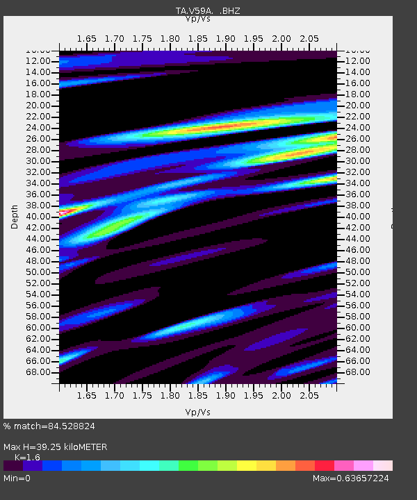
| Estimated Moho Depth: |
39.25 km |
| Estimated Crust Vp/Vs: |
1.60 |
| Assumed Crust Vp: |
6.565 km/s |
| Estimated Crust Vs: |
4.103 km/s |
| Estimated Crust Poisson's Ratio: |
0.18 |
|
| Radial Match: |
84.528824 % |
| Radial Bump: |
320 |
| Transverse Match: |
65.63121 % |
| Transverse Bump: |
400 |
| SOD ConfigId: |
769524 |
| Insert Time: |
2014-08-08 12:01:34.087 +0000 |
| GWidth: |
2.5 |
| Max Bumps: |
400 |
| Tol: |
0.001 |
|

Signal To Noise
| Channel | StoN | STA | LTA |
| TA:V59A: :BHZ:20140725T11:02:28.575013Z | 4.8406334 | 5.8705973E-7 | 1.2127747E-7 |
| TA:V59A: :BHN:20140725T11:02:28.575013Z | 2.69397 | 2.8705213E-7 | 1.0655358E-7 |
| TA:V59A: :BHE:20140725T11:02:28.575013Z | 2.588798 | 2.9430112E-7 | 1.1368253E-7 |
| Arrivals |
| Ps | 3.9 SECOND |
| PpPs | 14 SECOND |
| PsPs/PpSs | 18 SECOND |


