You are here: Home > Network List > TA - USArray Transportable Network (new EarthScope stations) Stations List
> Station W57A Gilead, NC, USA > Earthquake Result Viewer
W57A Gilead, NC, USA - Earthquake Result Viewer
| Earthquake location: |
Southeastern Alaska |
| Earthquake latitude/longitude: |
58.4/-137.1 |
| Earthquake time(UTC): |
2014/07/25 (206) 10:54:49 GMT |
| Earthquake Depth: |
10 km |
| Earthquake Magnitude: |
5.9 MWP |
| Earthquake Catalog/Contributor: |
NEIC PDE/NEIC COMCAT |
|
| Network: |
TA USArray Transportable Network (new EarthScope stations) |
| Station: |
W57A Gilead, NC, USA |
| Lat/Lon: |
35.15 N/79.99 W |
| Elevation: |
85 m |
|
| Distance: |
43.8 deg |
| Az: |
96.275 deg |
| Baz: |
320.247 deg |
| Ray Param: |
0.07230092 |
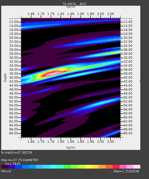
| Estimated Moho Depth: |
37.75 km |
| Estimated Crust Vp/Vs: |
1.76 |
| Assumed Crust Vp: |
6.565 km/s |
| Estimated Crust Vs: |
3.725 km/s |
| Estimated Crust Poisson's Ratio: |
0.26 |
|
| Radial Match: |
87.58229 % |
| Radial Bump: |
292 |
| Transverse Match: |
67.24247 % |
| Transverse Bump: |
400 |
| SOD ConfigId: |
769524 |
| Insert Time: |
2014-08-08 12:02:04.071 +0000 |
| GWidth: |
2.5 |
| Max Bumps: |
400 |
| Tol: |
0.001 |
|

Signal To Noise
| Channel | StoN | STA | LTA |
| TA:W57A: :BHZ:20140725T11:02:24.950013Z | 7.9362373 | 8.6669337E-7 | 1.0920708E-7 |
| TA:W57A: :BHN:20140725T11:02:24.950013Z | 3.3977976 | 5.220833E-7 | 1.5365345E-7 |
| TA:W57A: :BHE:20140725T11:02:24.950013Z | 3.239913 | 3.9407695E-7 | 1.2163196E-7 |
| Arrivals |
| Ps | 4.7 SECOND |
| PpPs | 15 SECOND |
| PsPs/PpSs | 20 SECOND |


