You are here: Home > Network List > TA - USArray Transportable Network (new EarthScope stations) Stations List
> Station X57A Johnson Farm, Hartsville, SC, USA > Earthquake Result Viewer
X57A Johnson Farm, Hartsville, SC, USA - Earthquake Result Viewer

| Earthquake location: |
Southeastern Alaska |
| Earthquake latitude/longitude: |
58.4/-137.1 |
| Earthquake time(UTC): |
2014/07/25 (206) 10:54:49 GMT |
| Earthquake Depth: |
10 km |
| Earthquake Magnitude: |
5.9 MWP |
| Earthquake Catalog/Contributor: |
NEIC PDE/NEIC COMCAT |
|
| Network: |
TA USArray Transportable Network (new EarthScope stations) |
| Station: |
X57A Johnson Farm, Hartsville, SC, USA |
| Lat/Lon: |
34.46 N/80.09 W |
| Elevation: |
133 m |
|
| Distance: |
44.3 deg |
| Az: |
96.996 deg |
| Baz: |
320.708 deg |
| Ray Param: |
0.07200067 |
| Estimated Moho Depth: |
36.0 km |
| Estimated Crust Vp/Vs: |
1.71 |
| Assumed Crust Vp: |
6.419 km/s |
| Estimated Crust Vs: |
3.754 km/s |
| Estimated Crust Poisson's Ratio: |
0.24 |
|
| Radial Match: |
85.84905 % |
| Radial Bump: |
400 |
| Transverse Match: |
42.965893 % |
| Transverse Bump: |
400 |
| SOD ConfigId: |
769524 |
| Insert Time: |
2014-08-08 12:02:50.407 +0000 |
| GWidth: |
2.5 |
| Max Bumps: |
400 |
| Tol: |
0.001 |
|
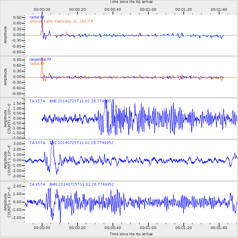
Signal To Noise
| Channel | StoN | STA | LTA |
| TA:X57A: :BHZ:20140725T11:02:28.774995Z | 5.672502 | 9.2566006E-7 | 1.6318373E-7 |
| TA:X57A: :BHN:20140725T11:02:28.774995Z | 3.9508872 | 7.585715E-7 | 1.9200029E-7 |
| TA:X57A: :BHE:20140725T11:02:28.774995Z | 2.9190354 | 6.0604816E-7 | 2.0761932E-7 |
| Arrivals |
| Ps | 4.3 SECOND |
| PpPs | 14 SECOND |
| PsPs/PpSs | 18 SECOND |


