You are here: Home > Network List > TA - USArray Transportable Network (new EarthScope stations) Stations List
> Station Y56A Pelion, SC, USA > Earthquake Result Viewer
Y56A Pelion, SC, USA - Earthquake Result Viewer
| Earthquake location: |
Southeastern Alaska |
| Earthquake latitude/longitude: |
58.4/-137.1 |
| Earthquake time(UTC): |
2014/07/25 (206) 10:54:49 GMT |
| Earthquake Depth: |
10 km |
| Earthquake Magnitude: |
5.9 MWP |
| Earthquake Catalog/Contributor: |
NEIC PDE/NEIC COMCAT |
|
| Network: |
TA USArray Transportable Network (new EarthScope stations) |
| Station: |
Y56A Pelion, SC, USA |
| Lat/Lon: |
33.79 N/81.30 W |
| Elevation: |
154 m |
|
| Distance: |
44.2 deg |
| Az: |
98.719 deg |
| Baz: |
321.266 deg |
| Ray Param: |
0.07206919 |
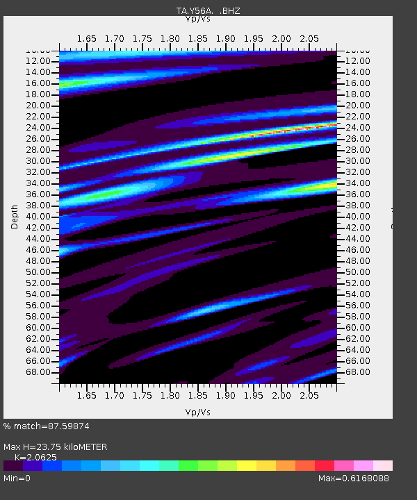
| Estimated Moho Depth: |
23.75 km |
| Estimated Crust Vp/Vs: |
2.06 |
| Assumed Crust Vp: |
6.565 km/s |
| Estimated Crust Vs: |
3.183 km/s |
| Estimated Crust Poisson's Ratio: |
0.35 |
|
| Radial Match: |
87.59874 % |
| Radial Bump: |
400 |
| Transverse Match: |
54.496975 % |
| Transverse Bump: |
400 |
| SOD ConfigId: |
769524 |
| Insert Time: |
2014-08-08 12:03:19.595 +0000 |
| GWidth: |
2.5 |
| Max Bumps: |
400 |
| Tol: |
0.001 |
|
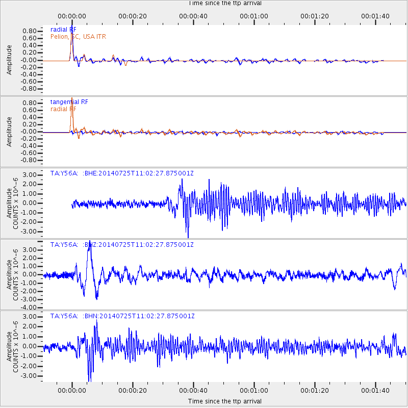
Signal To Noise
| Channel | StoN | STA | LTA |
| TA:Y56A: :BHZ:20140725T11:02:27.875001Z | 4.635031 | 9.1892184E-7 | 1.982558E-7 |
| TA:Y56A: :BHN:20140725T11:02:27.875001Z | 3.062348 | 6.224264E-7 | 2.0325136E-7 |
| TA:Y56A: :BHE:20140725T11:02:27.875001Z | 2.5066216 | 5.178213E-7 | 2.0658136E-7 |
| Arrivals |
| Ps | 4.1 SECOND |
| PpPs | 10 SECOND |
| PsPs/PpSs | 15 SECOND |


