You are here: Home > Network List > WU - The Southern Ontario Seismic Network Stations List
> Station PLIO Pelee Island, Stone Alvar Conservation Area, Ontario, Canada > Earthquake Result Viewer
PLIO Pelee Island, Stone Alvar Conservation Area, Ontario, Canada - Earthquake Result Viewer
| Earthquake location: |
Southeastern Alaska |
| Earthquake latitude/longitude: |
58.4/-137.1 |
| Earthquake time(UTC): |
2014/07/25 (206) 10:54:49 GMT |
| Earthquake Depth: |
10 km |
| Earthquake Magnitude: |
5.9 MWP |
| Earthquake Catalog/Contributor: |
NEIC PDE/NEIC COMCAT |
|
| Network: |
WU The Southern Ontario Seismic Network |
| Station: |
PLIO Pelee Island, Stone Alvar Conservation Area, Ontario, Canada |
| Lat/Lon: |
41.75 N/82.63 W |
| Elevation: |
143 m |
|
| Distance: |
37.6 deg |
| Az: |
91.834 deg |
| Baz: |
315.239 deg |
| Ray Param: |
0.07607295 |
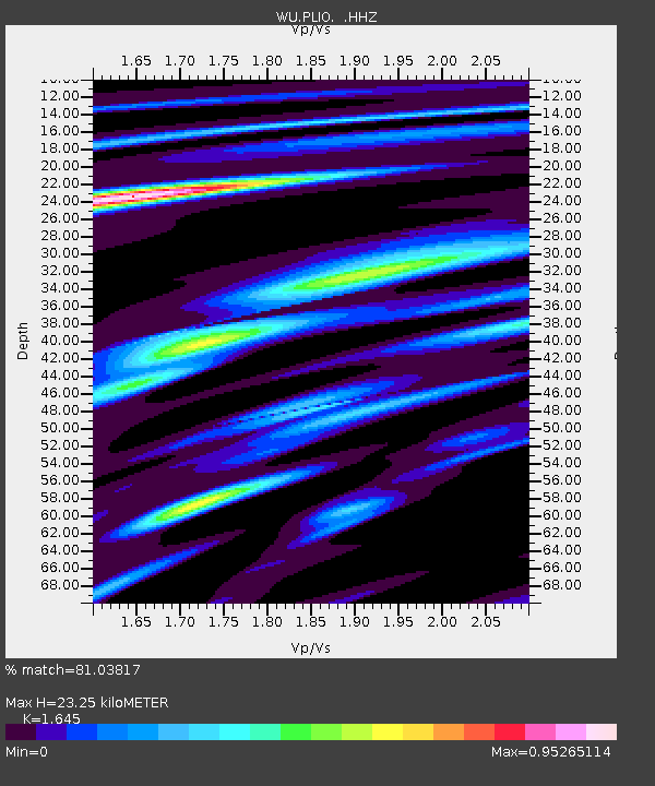
| Estimated Moho Depth: |
23.25 km |
| Estimated Crust Vp/Vs: |
1.64 |
| Assumed Crust Vp: |
6.498 km/s |
| Estimated Crust Vs: |
3.95 km/s |
| Estimated Crust Poisson's Ratio: |
0.21 |
|
| Radial Match: |
81.03817 % |
| Radial Bump: |
400 |
| Transverse Match: |
62.19625 % |
| Transverse Bump: |
400 |
| SOD ConfigId: |
769524 |
| Insert Time: |
2014-08-08 12:08:45.342 +0000 |
| GWidth: |
2.5 |
| Max Bumps: |
400 |
| Tol: |
0.001 |
|

Signal To Noise
| Channel | StoN | STA | LTA |
| WU:PLIO: :HHZ:20140725T11:01:33.250001Z | 3.6577806 | 8.6697776E-7 | 2.3702289E-7 |
| WU:PLIO: :HHN:20140725T11:01:33.250001Z | 2.9860208 | 4.276521E-7 | 1.4321806E-7 |
| WU:PLIO: :HHE:20140725T11:01:33.250001Z | 1.9167106 | 2.6432002E-7 | 1.3790294E-7 |
| Arrivals |
| Ps | 2.5 SECOND |
| PpPs | 8.7 SECOND |
| PsPs/PpSs | 11 SECOND |


