You are here: Home > Network List > II - Global Seismograph Network (GSN - IRIS/IDA) Stations List
> Station NIL Nilore, Pakistan > Earthquake Result Viewer
NIL Nilore, Pakistan - Earthquake Result Viewer
*The percent match for this event was below the threshold and hence no stack was calculated.
| Earthquake location: |
Irian Jaya Region, Indonesia |
| Earthquake latitude/longitude: |
-1.4/136.6 |
| Earthquake time(UTC): |
1996/02/18 (049) 02:25:36 GMT |
| Earthquake Depth: |
33 km |
| Earthquake Magnitude: |
5.7 MB, 6.4 MS, 6.5 UNKNOWN, 6.4 MW |
| Earthquake Catalog/Contributor: |
WHDF/NEIC |
|
| Network: |
II Global Seismograph Network (GSN - IRIS/IDA) |
| Station: |
NIL Nilore, Pakistan |
| Lat/Lon: |
33.65 N/73.27 E |
| Elevation: |
629 m |
|
| Distance: |
68.8 deg |
| Az: |
306.944 deg |
| Baz: |
106.693 deg |
| Ray Param: |
$rayparam |
*The percent match for this event was below the threshold and hence was not used in the summary stack. |
|
| Radial Match: |
86.13258 % |
| Radial Bump: |
400 |
| Transverse Match: |
85.2254 % |
| Transverse Bump: |
400 |
| SOD ConfigId: |
4480 |
| Insert Time: |
2010-03-02 00:28:53.876 +0000 |
| GWidth: |
2.5 |
| Max Bumps: |
400 |
| Tol: |
0.001 |
|
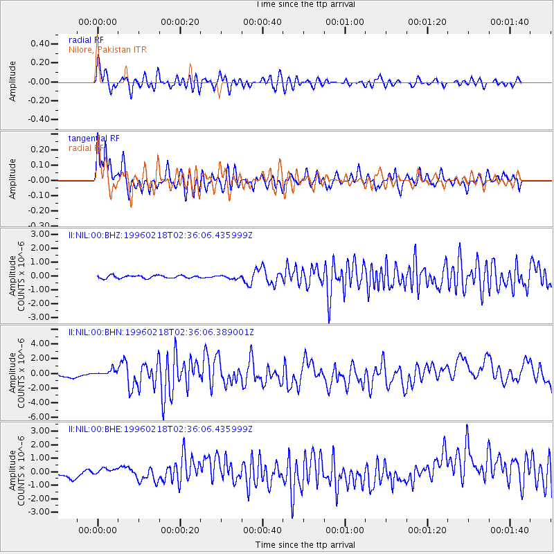
Signal To Noise
| Channel | StoN | STA | LTA |
| II:NIL:00:BHN:19960218T02:36:06.389001Z | 1.4238127 | 7.173551E-7 | 5.038268E-7 |
| II:NIL:00:BHE:19960218T02:36:06.435999Z | 1.04144 | 5.07437E-7 | 4.8724553E-7 |
| II:NIL:00:BHZ:19960218T02:36:06.435999Z | 1.0872238 | 1.1181824E-7 | 1.02847494E-7 |
| Arrivals |
| Ps | |
| PpPs | |
| PsPs/PpSs | |


