You are here: Home > Network List > II - Global Seismograph Network (GSN - IRIS/IDA) Stations List
> Station NIL Nilore, Pakistan > Earthquake Result Viewer
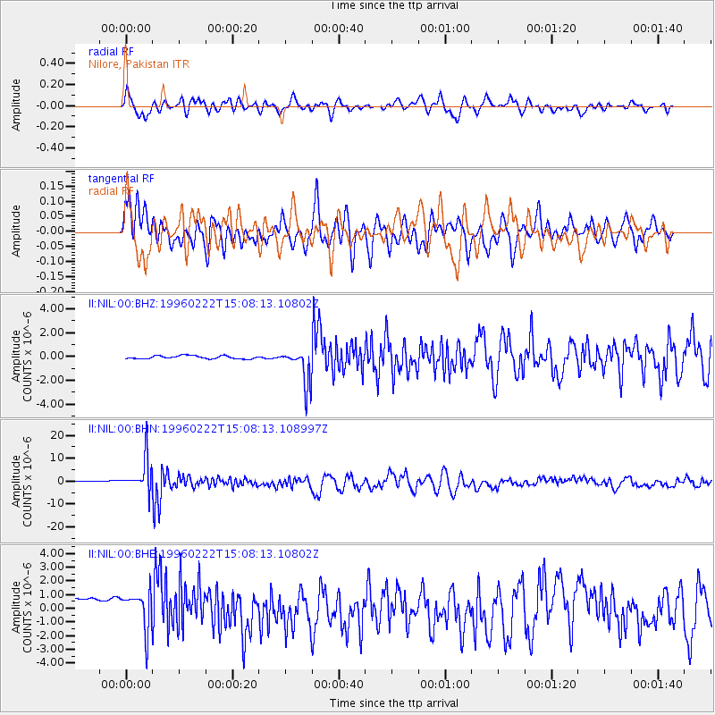
NIL Nilore, Pakistan - Earthquake Result Viewer
*The percent match for this event was below the threshold and hence no stack was calculated.
| Earthquake location: |
Kuril Islands |
| Earthquake latitude/longitude: |
45.2/148.6 |
| Earthquake time(UTC): |
1996/02/22 (053) 14:59:09 GMT |
| Earthquake Depth: |
133 km |
| Earthquake Magnitude: |
6.2 MB, 6.3 UNKNOWN, 6.3 MW |
| Earthquake Catalog/Contributor: |
WHDF/NEIC |
|
| Network: |
II Global Seismograph Network (GSN - IRIS/IDA) |
| Station: |
NIL Nilore, Pakistan |
| Lat/Lon: |
33.65 N/73.27 E |
| Elevation: |
629 m |
|
| Distance: |
57.3 deg |
| Az: |
286.571 deg |
| Baz: |
54.319 deg |
| Ray Param: |
$rayparam |
*The percent match for this event was below the threshold and hence was not used in the summary stack. |
|
| Radial Match: |
72.585014 % |
| Radial Bump: |
400 |
| Transverse Match: |
76.09506 % |
| Transverse Bump: |
400 |
| SOD ConfigId: |
4480 |
| Insert Time: |
2010-03-02 00:28:57.196 +0000 |
| GWidth: |
2.5 |
| Max Bumps: |
400 |
| Tol: |
0.001 |
|
Signal To Noise
| Channel | StoN | STA | LTA |
| II:NIL:00:BHN:19960222T15:08:13.108997Z | 9.362235 | 7.450037E-6 | 7.957541E-7 |
| II:NIL:00:BHE:19960222T15:08:13.10802Z | 1.6240396 | 1.4377391E-6 | 8.852858E-7 |
| II:NIL:00:BHZ:19960222T15:08:13.10802Z | 11.651877 | 1.5360631E-6 | 1.3182967E-7 |
| Arrivals |
| Ps | |
| PpPs | |
| PsPs/PpSs | |


